
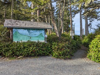
 I started my hiking in the Bere Point Campground by heading over to the Beautiful Bay trailhead, right across from my RV. Being this close was a minor negative to my campsite, as people going to walk the trail would be parking here close to my RV. But hey, internet signal where I am, and camper in the other direction. I decided for my first hike to just go to the viewing platform and to the beach access beyond that, coming back via the beach for a nice little loop. I planned to explore the rest of the trail when I had a full day to devote to it.
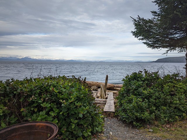
 The viewing platform is there to watch the whales according to the signs. You don’t want to disturb them by being on the beach when they are close in, rubbing themselves on the pebble beach. While I’d have liked to see whales, I knew it was unlikely as the salmon they follow were not around in numbers now, so the whales would not likely be here either.

Whale platform view
Really without whales, it’s not much of a view. But the information boards are nice, and you can always go down to the beach here and explore that too. But I was going down a little further, having not found the beach access at the platform on my first visit.
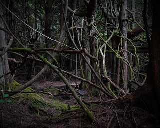

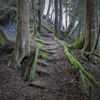
I notice walking along that there is a diversity of vegetation mixes along the path. The start of the trail had high walls of Salal, acting like a hedge maze you could not see through or go around at all. Then there were open sections with big trees. Then you come to this tangled mess of limbs and trees, something that looked like it might open up in a few years if these last stunted trees would just fall over and die already. Shelf fungus clings to many of the old trees, including this brown and white type I had not seen before out here.

The trail has sections of boardwalk along it to keep you off of the wet areas. It is not in the greatest shape. While I’d rate the trail to the viewpoint as easy, beyond that the trail is more difficult. I’d give it an intermediate rating, other than the hazardous sections of boardwalk. They are slippery and broken, or in danger of breaking from the next step on it. You need to be paying attention to the trail rather than taking in the scenery as you walk.

Beautiful Bay looking to Malcom Point
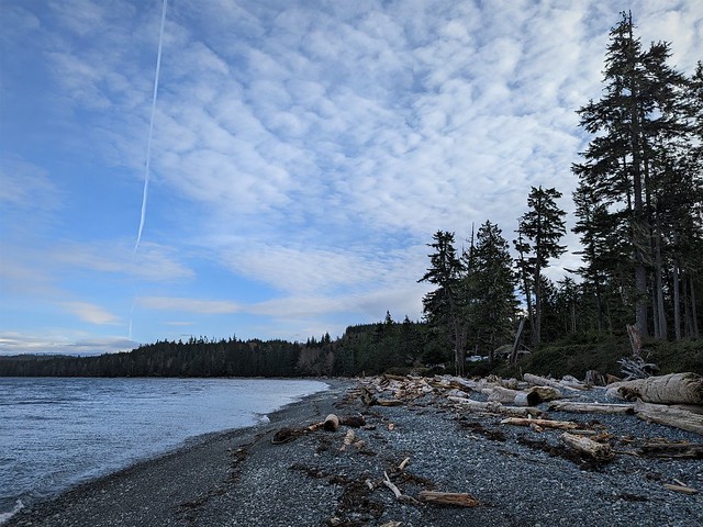
I ventured a bit beyond the second beach access, hoping to see the ‘big tree’. Having encountered the treacherous path, I decided to leave that for another day. I came down to the beach on the access past the viewpoint. The beach was more of the gravel type further up. The clouds had picked up a bit – weather was starting to come in. I could see Malcom Point at the end of the bay – I hoped to hike out there one day while I was here.

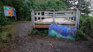
Bere Point Research hut
Walking back down the beach I encountered what looks like a tiny home. It seems to be in use – there are solar panels, radio antenna, and a boat sitting there. Doesn’t seem like someone would be living here, being so close to the campground, I thought. Looking at the other side, I saw a sign “Bere Point Research”. Now it makes sense, this is a research station, probably there primarily for the whales that come here to rub on the gravel beach. You can see they are trusting out here – there is a boat and motor just left out here, the only security is padlocks on the building, and I’d guess the boat and motor might be chained up, but who knows, I wasn’t checking as I’m not interested in taking a new career.
Beach at Bere Point campground
I arrived back at the campground, seeing the beach here is strewn with deadwood. It is just thick here. I needed to pick my way carefully through the logs, and stepped on them gingerly, as they can be very slippery. But I make it back to the trailhead without falling, this time.

There is an informal monument of sorts, a bunch of wood signs and floats, carved and painted with the names of those gone but not forgotten. This isn’t the first of these types of monuments I’ve encountered on beaches. It seems to be a thing people do to remember those who have passed on.
View from my camp
I enjoy the view from my camp as the clouds roll in, remembering those I knew who no longer roam the earth with me.

Light ahead in the dark forest
The following day I decided to head further down the Beautiful Bay trail to Puoli Vali Canyon. The trail beyond there was closed according to a sign, yet only for the winter. I’d see for myself what the trail looked like beyond the canyon. If I had time, and the trail didn’t look too bad, I’d head to Malcom Point.
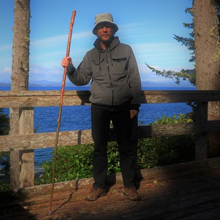
My first stop is at the viewpoint. The railings around the platform make a convenient prop for my SLR, so I take the opportunity and do the selfie thing. For you old folks, I took a picture of myself.
The trail beyond the viewpoint becomes somewhat indistinct in places. But there are many trail markers, in this case, white rectangles painted on the trees to guide me. Any experienced hiker should never really get lost here – the ocean is always within hearing distance, and usually you can see which direction it is in through the trees. It is good they have the markers – I walked off the path several times in the open forest without realizing it. The markers help you make sure you’re still on the trail. When in doubt, first thing I looked for was a marker.

The big tree gives me another selfie opportunity, although the sign could be more distinct. If I show this without flash, the sign is a bit more readable, but still faint. I’d be in the shadows too then.
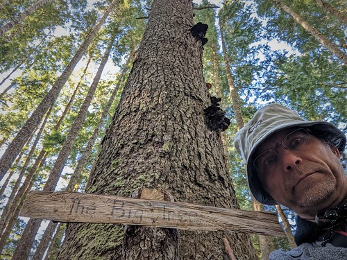
Well, there is this close view taken with the phone, at least you can read the sign. The big tree is large for the area, but I swear there is a bigger tree I passed just before this one that is bigger yet. Perhaps they refer to height here, as the signs say this Sitka Spruce is 64.6 metres tall.

Puoli Vali top of Canyon bench
I eventually arrive at the top of Puoli Vali Canyon. There is a bench here, not so much for the view, but for the rest you will need coming back climbing the stairs. The sign here warns that the trail is not maintained beyond this point, use at own risk.
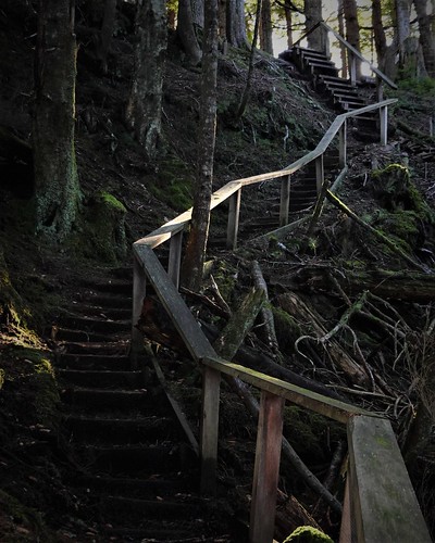
Considering that the first set of steps down have two missing steps, I take the warning seriously. I’m not assuming anything is solid here, especially considering that the ‘maintained’ section of trail also has rotten and broken planks on some boardwalks. Looking back up, I see this is going to be a workout coming back.
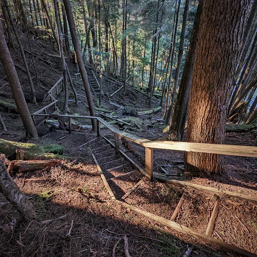
Looking down, I see there is a long ways to go. There are several tricky bits with a tree over one section of stair, and crooked boardwalks that are missing bits. I can see this part of the trail has had some maintenance in recent years, but nothing to fix the latest issues. Perhaps they fix it up in the spring before considering it open for the season.

Beach at Puoli Vali, Malcom point in the distance

Beach sign Puoli Vali Canyon

I reached the bottom of the canyon and hopped out onto the beach for a moment. It is more of the rocky beach you see along most of this side of the island. I can see Malcom point up ahead. But I’m only half way through the 5km hike and the day is already later than I expected. That tough and winding trail slowed me down a lot. I decide to check out the continuation of the trail climbing out, but I’m already thinking I’ll be turning back here. I contemplate the kelp float carving that washed up here, or was left behind by a recent visitor. It’s a cute sea-Halloween theme, and biodegradable to boot.
Stairs up the other side of the canyon
At the first set of stairs, I saw that this section is in much rougher shape than what I just passed. Considering how much I was slowed down on the comparatively good trail, I decided to call it a day and hike back. I’ll reserve trying to get to Malcom Point for a full day hike, even at only five kilometers.
The canyon had some gold panning activities in the early days. I returned on one of my last days here to try my luck. I am no richer for that experience. I did manage to make it back here a with a full days time allocated to continue my hike as well. Those adventures I had in Sointula and surroundings in the meanwhile will be in my next blog.
I’ll continue here with my third trip down the Beautiful Bay trail. By now I was familiar with the sites and mostly made time straight for the canyon. The trail still had me doubling back once in a while where I shoot off it – the markers are good but a few places are missing a mark to keep you on the trail. I’ve started early and had lunch at the canyon, before continuing up the other side into uncharted territory.
The trail up the other side of the canyon is fine, but I need to watch every boardwalk and bridge for rotten steps. I make sure to step on the strongest part, never trusting that the board will hold.

New trail to the left, old trail to collapsed section straight ahead

New trail being built
The trail winds up the west side of the canyon, crossing the creek again, and continuing its climb up the the east side. Suddenly, I encounter unexpected trail reconstruction! It seems the old trail has collapsed into the canyon and a new trail is being built higher up. I can see the step construction ends up above with only some earth digging. I see that a path has been trodden just above the collapsed section of trail. I decide to take this old trail, not being certain the new trail has been completed to connect with the original trail. It ends up being a pretty rough section, with people walking above the collapsed area. I can certainly see more of this area collapsing into the canyon with heavy rains. Hopefully this is the beginning of more work to fix up the other parts of the boardwalks, stairs and bridges that are in poor shape.

Rotten crooked bridge
I crossed the canyon again and made my way up and out following the trail. I had to concentrate on keeping on the trail, confirming my direction with the tree markings as the trail was quite faint here in places. Even the tree markings were not as frequent, and only painted in old faded blue paint. It is a long slog, but at least not so wet with rotten boardwalks. As the trail dropped down close to the beach, I could see some recent maintenance had been done to clear heavy brush where required. Those sections were easy to find. The bits in the open wood required a bit of back and forth at times to be sure I was still on the trail, and find the next mark confirming that. As I got close to the point the faint trail stayed close to the beach. I mark a spot close to where the trail goes away from the beach. I wasn’t going to get lost, but I had to make sure I could find the good trail back off the beach on the way back.

Malcom Point looking to Fort Rupert
I reached Malcom point, with the trail dumping me out on the gravel beach. The point gave me a view looking back to Bere Point, and out over Queen Charlotte Strait to Fort Rupert. It wasn’t much of a view for the work I had put into it, but that is the way it goes – not every destination’s beauty matches the effort put into getting there. I still take a good break out here and enjoy the sea air. There is no one out here, just me and the birds.
 It is a long ways back, and I needed to start my return soon enough. It was a good thing I marked where the trail turned away from the beach – it was hard to find that turn and my mark was useful to get me looking where the spot was.
Once I found the turn, I spent a bit of time putting a bit of flagging tape on the actual turn for the next person, so they don’t miss the turn either. I have been doing minor trail clearing all along as I walk back and forth down this trail – there is now less debris and more markings along the trail – my bit to leave things better than I found them. I enjoyed walking along Beautiful Bay, even if the trail was a bit rough. Especially the long journey out to Malcom Point left me good and tired at the end of the day – no complaining about lack of exercise for me!
Join me in my next adventure, when I decide to explore more civilized parts of the island by visiting the village of Sointula and its surroundings.
