 I had decided to head south rather than west or north for my next adventure, to Kitimat. My scouting of Prince Rupert so far wasn’t looking promising for ocean camping, but perhaps Kitimat might have something at least along the river. But my plan was to be thwarted, along with Plan ‘B’. Come watch me adapt and go with Plan ‘C’!

Fox Glove Flower
I arrived in Terrace stopping where the tourists are all supposed to stop: The Visitor Centre. My main query was what kind of boondocking free camping there might be at or close to the ocean to launch my kayak. The ladies weren’t too knowledgeable on that front as expected. Tourism information is geared towards activities that part you from your money. While boondocking in an area does lead to me spending some money on resupply, the activities result in comparatively few dollars spent as compared to someone coming in and staying at a hotel for the weekend. I try to eat out while I’m in an area, but my spending is nothing compared to someone in an RV park or hotel. I do have to give Terrace Visitor Centre points for having a free dump station and potable water. That is exactly the kind of thing that is going to draw me to an area.
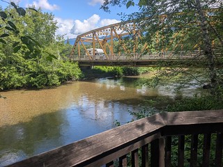
You cross the bridge and then go to the platform.
As I was heading to Kitimat, the ladies suggested I check in at the Kitimat Visitor Center to query them about possible camping / ocean access; they would know that area in more detail. I wasn’t expecting any good boondocking tips, but I thought it might be worth a visit to find out what my ocean access options were down there. I proceeded down Highway 37 to Kitimat, only an hour down the road. I wasn’t in for a long day of driving here, so I had time to do things like visit visitor centres. I made one stop along the way at the north end of Lakelse Lake Provincial Park, where there is a little walking trail leading to a salmon spawn viewing platform. I was hoping there might be some boondocking here, but not not really. I contented myself with the walk, which was strange, as you took the trail back to the main highway, cross the highway bridge, then take the trail back down the creek a short distance to the viewing platform. It just feels like you are backtracking, and walking along the highway isn’t relaxing for sure.

Kitimat Visitor Centre
I continued into Kitimat after this less than impressive stop. I was parking at the Visitor Centre, with an eye of just walking to the McDonald’s next door for lunch after. The ladies at this place were more knowledgeable about the area, including being able to warn me that the road to Enso Recreation Site was washed out. This was the site I had planned to go to, being not too far from Kitimat, with the idea being I could ride back into town on the Grom and explore around a bit. I got some ideas for launching my kayak too, but there doesn’t seem to be any good boondocking near the water other than possibly Minette Bay West Park for a night of stealth camping to launch from the water there.

Closed with a big ditch dug on the other side.
After my lunch, I continued out of town north towards the Enso site. My ‘Plan B’ was to camp somewhere along the way before I hit the washout, I hoped. I had scouted some spots on the aerials that looked good. Unfortunately, I hit the road closure way sooner than I’d hoped, with not much available for boondocking up to that point. Had I been pushed for time or options, I could have made something work, but I had a ‘Plan C’ to try south of Kitimat, following the improved road to a cancelled LNG site to see what was available along there.

Rio Tinto Aluminum Smelter

New LNG Construction
I drove back into town, heading out south this time past the Aluminum smelter that is the reason Kitimat exists today. It’s big, with a lot of buildings stretching out along the road. I turned off down an improved gravel road where I had been warned by the tourism ladies that there was active construction, but once past that I’d be good. Indeed, there was construction, but it was all well marked and safe to pass, as safety is taken much more seriously these days at all big construction sites.

Boondocking spot V1
I was hoping to go up a forestry road that branched off not too long before the cancelled(?) LNG site. Indeed, I found the turn and the road heading across the creek and up the hill. But it was quite overgrown, which I found out quickly was due to a ditch having been cut in the road just as it started climbing the hillside. There was a little pullout there which I tried to level at, but it wasn’t great. After a few minutes of trying to level, I decided that being near the main gravel road wasn’t too bad, and I pulled in at a bigger level spot just past the bridge but still visible from the main road. I wasn’t expecting the main road to have a ton of traffic (and dust) so I decided this spot would do. I at least had a creek just a short walk away to go cool down in – things had gotten to a proper summer heat finally in this part of the world.

North Cove Trailhead
I settled in, having dinner followed by an evening walk. Of course, I immediately discover a better spot just a bit further down the road. That spot has a nicer clearing, but I’m not sure you could get down to the creek running nearby. There are other spots around the area. If you just wanted to overnight and have a nice hike to go along with it, the North Cove Trailhead has plenty of space to ‘park’ for a day or two, with the added bonus of having a nice 3/4 hour hike down to the ocean to enjoy.

The two bridges near my camp, main road is the closer one here.
The spot I had picked did turn out to not have much traffic, although there could be a bit of dust blowing over you from a passing vehicle if the wind was coming from the south. There were only a few cars a day, with a few work vehicles going over to that LNG site. I’m still not totally sure that project is abandoned even though Reddit says so, it may still resume under new owners. The site I passed closer to Kitimat is definitely under construction. It’s not a large space, it may only be a new berth for tankers. I’ve not bothered to research further, it could end up being something way bigger by the time it is done. At any rate, there is a fair bit of activity in the area, so any advice I give you on boondocking here may not be valid in the future if new construction happens.

Good dump facility at the park
I spent some days exploring the wilderness around Kitimat and a day exploring Kitimat proper. Kitimat isn’t big, a day is plenty if you are just going to hop from place to place. The first stop I made heading back into Kitimat was Radley Park. It’s actually a campground, setup nice for small to medium sized rigs. You could bring a monster rig in here, but the choice of spaces would be limited. From my perspective, the best part of the campground was the free dump station and potable water, another tip from the ladies at the tourism bureau. The setup is pretty decent too, although for my left handed dump it means fill water first, then drive up to dump. The campground is along the Kitimat River, on the opposite side of the road from the town’s industrial area. You won’t see the industry – there is pretty good tree screen from that. You could walk into the commercial part of town following the main road over the river, but it is a bit of a trek. The campground is also located quite a ways up the river for getting to the ocean.

Boat launch, sign says private, blah blah blah, no overnight camping
You could take a boat down the river to the ocean, but I think you’d be better off using Rio Tino’s boat launch that they have kindly let the public use as well. It’s south of Hospital Beach, next turn left past that spot. Sometimes you can boondock at these boat launches, but Rio Tinto explicitly bans overnight camping here. Evidently Hospital Beach is the original commercial area of town, as this is where the original hospital was, along with the original HBC store in the area.
 Remains of the original HBC |
 Foundation of the original Hospital |
 I continued on into town, making a quick stop at the fish hatchery, this being a salmon hatchery for salt water fisheries. There wasn’t much to see there other than a salmon head drop off box (research can be yucky at times). If you had to, you could park overnight here before the entrance. It seems that people do that, but I’d pick a quieter spot. Next door is the informal Squirrel Park, which has some memorial trees. I’ve seen this sort of thing before – local tree(s) gets various signs and bits attached to it to memorialize a passed loved one, animal or human. It is a nice shade spot to hang out at, with a handicap access point to the river for a view and some fishing. The platform to fish at is nice, but you still need to get to it over rough terrain with a wheelchair. This is a common problem: access for wheelchairs is incompletely built, leaving a difficult to impossible to get to spot. Build less, but build right I say.

Early Kitimat residential area (museum photo)
The central part of town contains a retail complex with all the shopping and municipal services. Kitimat is a planned town, the first part having been built in the early 1950s. Wikipedia makes it sound like a wonderful thing, with the central retail/services district I was in, with low density residential around it, and the industrial zone well separate on the other side of the river. Everything is separated by green belts with paths to walk between them. While I’d say it is a car paradise, it ain’t great for walking. What do you expect for something planned in the the 1950s?

Mall art
My goal was to hit Two Peaks Brewing for a beer and a bite (it was OK), but first I decided to explore the retail area a bit. You can see that a lot of the original mid century design elements remain behind, with some updating happening over the years. It’s not exactly booming, but some modest expansion has occurred over time. I walked into the City Centre Mall, which wasn’t quite a dead mall, but it’s not thriving either. There was some interesting native art on the walls, and for some reason the designers decided this had to be a two level mall even though the rest of the town sprawls every direction in its design. But the compact design doesn’t help the occupancy; big box retail stores are the newest buildings in the area having taken over a lot of the mall’s business. Fields is the anchor tenant in the mall, a small department store chain that exists in the smaller towns that Walmart has deemed too small for a store. They compete with Walmart on the gas price to drive to the nearest one. You’re an hour drive to Terrace for a big Walmart shop, so it’s not worth the gas money if you just need some basic cheap stuff. Walmart has gutted the Canadian retail landscape; there are few department store type chains left.

Two levels of dead mall

Stuffed menagerie at the museum
The town’s museum was right next door, small but dense in displays. Unfortunately, I couldn’t see the upstair level here as it was closed for a relocation. The lady running the place was quite nice and we chatted for quite a long time. She felt the town’s economy was somewhat depressed with the loss of forestry jobs in the area. I guess it’s all a matter of perspective. I’ve been all over BC and the loss of forestry jobs is universal. Pretty much every town has taken a hit on that one. To me the town felt like it had some life in it, with modest growth to be seen in town thanks to the new industry building in the area. Even the museum was looking for a bigger space for all its exhibits. It certainty feels more lively here than a lot of other BC towns where the only saviour is tourism.
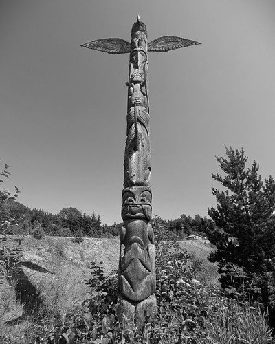 I toured around outside town on the Grom too, looking for other potential boondocking in the area. I drove down the east side of the inlet to Kitamaat Village, the original native village that watched Kitimat being built in the 1950s. The road to the village has some potential spots, but I’d classify them more as one night layover places. There was nothing with good ocean access to be found. In the village, I was happy to find a nice totem pole there, even if it wasn’t painted. There is not really much for tourists here otherwise. But I was trying to find boondocking beyond the reserve surrounding the town anyways.

Spot by incomplete tower
There is an access road that leads to a power line, with a gate that seems to be permanently open. But the area could be closed, especially if construction work is happening in there. I went down one side road that was access to some of the electrical towers, including one that sat there incomplete with no wires going to it. I’m assuming some construction project got cancelled when this was in mid-build so the tower got left for potential future use. You can even camp there, although the road up to the spot is rough and could be overgrown on a return visit.

Big Boondocking space
I went further down the power line access road, to a spot that looks like a recently cleaned up staging area. It is all nice and flat and gravelly (with some mud) right now, so an easy spot to camp at. The spot is plenty big to give you lots of sun. I might come here should I revisit the area and head further down that road to see if there is some ocean access further up. It looks like a possibility based on the googles map. If I wanted to be closer to town, there was a recently logged out area going to the right at the water tank junction, there was a little staging area a short distance down that even had a bit of a view and lots of sun.

Native Art inspiration
I explored around where I was camped as well. Other than the one good spot close to my camp, I was surprised to not find much further down the road. You don’t really want to camp at the end of the improved gravel road as technically you are on a reserve – you might get booted out. I expected to find some good spots along the forestry road that continues past here, but not really. There were some spots, but all far from water other than the remains of an old pit filled with water that was very brushy to get to. I was hoping to check out the trailhead to Jesse lake down the road, but it was so overgrown that even with the Grom it became too much between the branches and the rough road. Coming back, I pass a van going in, who was definitely pushing the bush so to speak. The van never came back when I stopped for a break, so he may have parked at a pullover, or kept going to the trailhead. It goes to show you, even if an area looks promising on an aerial map, sometimes it still doesn’t yield much for camping.

North Cove Trail
My last day I took the Grom over to the North Cove Trailhead. There has been some remediation in the area so they have blocked off what would be some good boondocking areas a bit more screened with trees. Now you just park with the others at the trailhead. At least you can park away from them a bit if you want. The trail down to the ocean starts on some recent growth (logged) forest, so it is very dense vegetation. But as you get further down, you get into original growth forest that is more open and interesting. The sign at the trailhead tells you to look for Cedar trees that have had their bark stripped off by the natives for crafting. Indeed,I did find some – you can see the little knife notches where they cut into the tree a bit as they cut the bark.
 The ocean area is nice, but the picnic area is in disrepair. The toilet is out of commission, and the picnic tables are slowly being eaten by the forest. But you can still access the ocean and do a bit of beach combing. I never found any other facilities following the sign to the other picnic ground, just a swing with some carved words on it. It’s a nice area – I only wish I could have gotten my kayak down there but it is a bit far to walk with that in tow. I splashed a bit of salt water around and called it a day.


It was time for me to head to a new spot. At my last site, a local had told me about an ocean access that was supposed to be down a logging road before Prince Rupert. I had figured out that this was Work Channel, where an informal boat launch was being used by the locals. Join me next time as I go see if I can finally launch my kayak in the ocean!