
Molas Pass is almost 11,000 feet
I got an early early start, knowing that I was crossing Colorado south to north through what would be some slower mountainous roads. I did not realise just how high the roads were, nor that I could end up in snow even though it was now late May here. What other surprises awaited me?
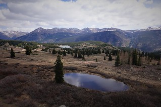
 My plan was to head north from Durango up highway 550, hitting Montrose and Grand Junction on my way to the I70. But the map failed to explain to me just how dramatic this road through the Rockies would be. I would be crossing over three passes all over 10,000 feet, with Red Mountain Pass at just over 11,000 feet! The road is not for you if you have a fear of heights or tend to ignore recommended speed limits on sharp corners. One mistake here can plunge you down a mountain for a thousand feet. But the views driving were spectacular, when you could afford a glance while navigating the winding switchback laden road. I made several stops to capture some of the spectacular views in what was very early spring up here still with the melting snow.
 Lunchtime had me only as far north as Ouray, where I stopped and ate at the rooftop patio of the Ouray Brewery. This is an excellent venue, with a great beer and burger to enjoy with the view of town and the mountains I had just driven through. Sated, I drove on, making much better time now that I was not on narrow windy roads anymore. Grand Junction gave me a chance to fill up with propane at a KOA of all things. Expensive to stay the night, but the propane was reasonable. The attendant told me they have not changed the price in many years, for what that is worth.
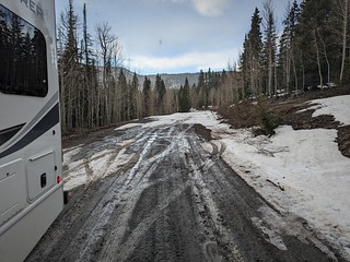 Hitting the Interstate 70, my ride was uneventful, although there is still some good scenery along here to Rifle, where I turned north on the 13, taking me north from Craig to Routt National Forest, where I planned to camp at a site in the hills. What I didn’t account for was that the hills here are over 10,000 feet tall, and I’d be above 9000 feet. Sure enough, I see solid snow on the road ahead. I look at the map. The campground is still several miles ahead up the hill. There will be no going to this campground for a few weeks yet! Fortunately, I had spotted some boondocking spots further down just off the road. One of those would do. I decide to back my way in, doing my usual poor job and being too close to the lower side of the camp road.
 I try to maneuver, and find myself quickly stuck in what turns out to be pretty wet black dirt here. Further attempts to get out just get me sliding further down the right, into some Poplar stumps. I manage to get myself on a couple of very muddy blocks, getting myself just level enough to run my fridge (not very level). The day is late, and I’m not going to try to get myself out in the dark.
 But the following day dawned clear and quickly warmed up. I assessed the situation on a fresh brain and saw that with some patience and a lot of labor, I could get myself out. I just needed to dig a bit, and get some gravel from the road underneath my tires to give myself traction to move. A morning’s work and I was out and back in the middle of the spot just a few feet back of where I had been stuck. I’d be adding a bit more gravel to the exit during my stay there to make sure I got out without issue! I have to say, that was a relief being un-stuck. You are never totally sure until you are out just how hard it will be to extract yourself from your hole. I was free now to enjoy the spot for a few days, especially since the forecast was dry so the area would have time to dry out more before I left.
 My first hike higher up confirmed that there would have been no going to the campground. Even to walk I’d have needed snow gear, my little loop road that took me into the snow had a couple of feet or more of snow on it in places – as I found out breaking through the crust every now and then.
 But my hikes on the lower trails were great. The flowers come out quick here after the snow melts, including some specimens very similar to my rock garden flowers back home. The trails here are not well tread. I found I had to pay close attention to not wander off the trail. Even so, I still managed to get off the trail a few times. But the open terrain and a map on my phone meant I was never lost – I could always track back if I wanted to.
 As the Memorial Day long weekend was coming up in the States, there were other people around camping. I had several vehicles drive past to only return the other way, seeing the same snow and impassable road up above. There was not really anything open yet for camping above my spot, at least not without a lot of mud. I ended my visit before the weather turned rainy according to the forecast – I wasn’t going to chance getting stuck again! Colorado had been great camping in the highlands during the spring. I would not get the chance to do that if I follow the normal snowbird routine because I’d be back in Canada by now. I was headed north again, this time back to a familiar spot I knew I could get in and out of in the rain for the Memorial Day long weekend. Read on to find out where that spot is!
