My before dawn rising to head to the airport is probably overkill, but I’ve seen enough of Phoenix’s traffic jams that I’m not taking any chances.
At any rate, I’m up in the predawn, a few minutes before the continental breakfast is supposed to start in the dining room of the American Inn. I do a quick wash and head down. The continental breakfast offered is a basic fare, but they do have a waffle maker if you wish to partake. I’m sticking with toast and coffee. The room has a view of the indoor courtyard – I get to watch the sky slowly start to lighten up with the new day. I was hoping to have the place to myself or at least just a quiet couple of people. But a whole family arrives shortly after me, with their morning chatter.
–
I keep an eye on the googles traffic for the Phoenix freeways. I see an accident already on one of the freeways that is backing up traffic near my route to the airport, so I decide to get my cab early and head out. There is no peace here anyways. I get the front desk to summon a cab, which arrives quickly. Time for my last journey in Phoenix. Upon entering the freeway my cabby notes the traffic on Superstition freeway is backed up. It seems the accident backup has made it all the way back to me already. The cabby immediately exits the freeway again, saying that the side roads will be faster to get to the airport. Phoenix has a nice grid system of streets – hard to get lost on them, and straight forward to go around problems. We arrive at the airport probably about the same time we’d have spent delayed on the freeways, but I would rather keep moving, plus I get at least a little bit of a view of Phoenix. It’s not much to write about, typical suburban sprawl. I could have been in any big city in the USA or Canada frankly.
I arrive at the airport extra early, and just hang out for a bit. Eventually I decide it is time to go brave security and see how I fare this time. My previous trip to the San Francisco resulted in a full search and swab procedure thanks to my bad luck of being closest to a bag going through the scanner the security thought was suspicious. My body seems to be full of metal according to the American body scanners. There is not much of a lineup, which is good, because there is only one screening area open and it’s minimally staffed. The keep yelling to the back of the line for everyone to keep their stuff in their bags, just put everything in a tray. You still have to take your shoes off. How unusual. Everyone gets a go through the body scanner. I do my turn, with the the usual pause at the end. I’m expecting another pat down. But the guy just says “well, I don’t know what I’m going to do about that” and waves me on. I can see “boxes of concern” on the scan, but it seems today they are more worried about speed rather than detail in scanning. I collect my stuff and head on, happy to be done without being patted and swabbed.
 |
| Downtown Phoenix from Sky Harbor Airport |
More waiting and eventually I’m on the plane. We are taxiing west, affording me my only good view of downtown Phoenix. It’s a pretty sparse skyline compared to Calgary, but considering the sprawl of this area, I am not surprised at that.
 |
| Sky Train Station Terminal 3 |
I am more surprised by the amount of infrastructure dedicated to their people mover. The Sky Train is the people mover for the airport, taking you from the light rail station, to terminals 3 & 4, parking garages, and shortly, the car rental area. The train literally takes you from corner to corner in the airport property, for a cost greater than what we built an LRT in Calgary to the ‘burbs for. I’m all for investing in public transport, but this seems a little excessive to me. But it will be nice to just be able to roll your luggage of the light rail, onto the Sky Train, and off again without ever having to lift anything on a shuttle or bus.
 |
| Sky Train Construction to Car Rental Area |
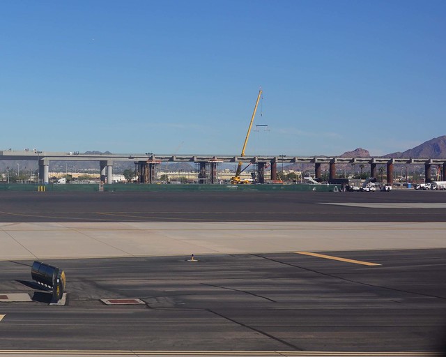
I can see from the construction that they are close to finishing the last leg to the car rental area. My reading tells me that the scheduled opening for this segment is 2020. The irony is that this section that completes the people mover is building to the car rental section of the airport. Take the people mover one way and rent a car, or take it the other way and hop on the light rail line. At least you have the choice.
We take off to the east, I engage in my favorite pass time flying: taking pictures out the window. You get the best pictures when the plane is taking off and landing. A jet flies too high to see much ground detail at 40,000 feet, although you can get some cool cloud pictures sometimes.
 |
| I10 and 143 Interchange |
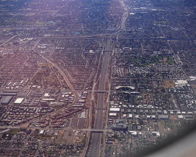 |
| Highway 60 and 101 Interchange |
 |
| Trying to get a Picture of Cruise America as we turn Blurry on the very bottom! |
Leaving the Phoenix area, I try and get a picture of Cruise American, where I rented my RV from. The plane banks to the left to turn north just as I’m trying to snap the picture so I only just manage to get it in the blurry bottom of the above picture. The banking plane puts the window too much into the sun, so my next few minutes is looking out at the east Phoenix area in the glare. But as we get to the northern end of the contiguous sprawl, the plane levels again and I get a few shots leaving Phoenix, plus some of the suburban bedroom communities north of Phoenix.
 |
| Arizona Canal and Beeline Highway |
 |
| Fountain Hills, north of Phoenix |
 |
| Rio Mountain Estates, north of Phoenix |
The sprawl of Phoenix is truly massive, going from continuous development to only small towns separated by much desert. It’s hard to even mark the edge of the ‘burbs, but I’d call Rio Mountain Estates the northern edge, as the hills start limiting development north of here. I note as we travel north more of the large infrastructure for watering all the ‘burbs. Canals and reservoirs north of Phoenix support the needs of the city, diverting water from the Colorado river via canal, and storing water from the hills in reservoirs. Phoenix as a large city is impossible without all the water being diverted into it; and would be mighty uncomfortable in the summer without the modern invention of air conditioning. But with those two, Phoenix has become a great winter escape for the snow birds, and tolerable in the summer as long as you stick to indoor air conditioning. Phoenix does have one natural advantage as the hills I am flying over are a lot cooler in the summer – you can escape the city for outdoors in the much cooler hills in the summer.
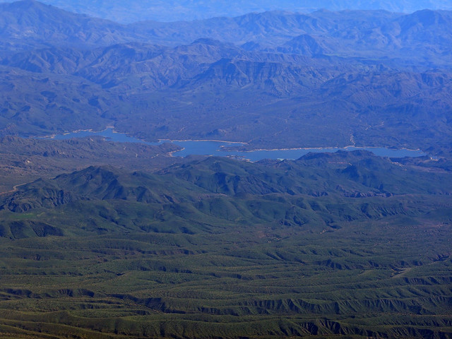 |
| Bartlett Reservoir |
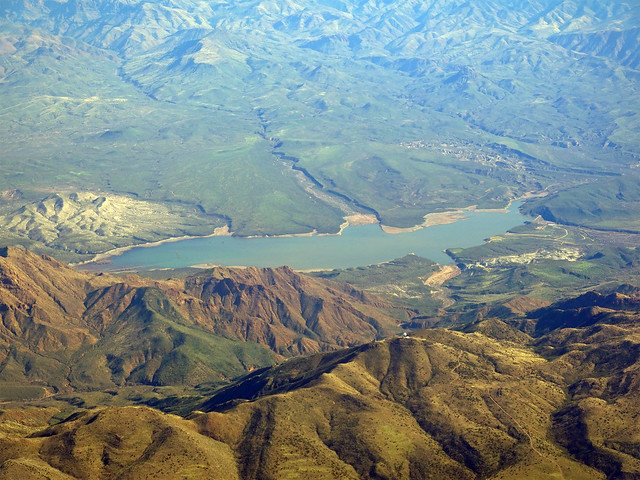 |
| Horseshoe Reservoir |
 |
| Camp Verde |
Camp Verde is along Interstate 17, about half way between Phoenix and Flagstaff. It looks more like a size of town or small city I’d like to live in. It just needs to be big enough to provide all the day to day services. Bonus points if a big city is within a couple of hours drive for more specialized needs. The hills around town look like they would be interesting to explore too.
 |
| Verde River and Interstate 17 |
 |
| Red Outcrops South of Sedona |
The skies continue clear heading north – unusually clear viewing from 35,000 feet today. I start to see red and white outcrops of rock, looking like teeth sticking out of the vast landscape. The colors are vivid in the morning light. I wonder what it would be like to explore the canyons and valleys down there. There are so many to explore, and they keep coming as we fly further north.
 |
| Sedona and Hills |
 |
| Bear Mountain and surroundings |
Passing the red rocks, I am flying just a bit too far west to see Flagstaff properly, but I do see the Arizona Snowbowl, one of the ski hills in the State. Arizona is blessed with a variety of topography – you can be getting a tan in the desert one day, then carving power the next day, with a not too long a drive in between!
 |
| Arizona Snowbowl |
I had been hoping the good viewing would hold until we flew over the Grand Canyon and I was not disappointed. The Grand Canyon impresses from any perspective: down in it, viewing from the rim, viewing from 35,000 feet, or viewing from space! I can almost see where I hiked down, but the plane is flying almost over it so my views are best to the west of the area. It is a spectacular view today, and I see just how much more I could explore down there.
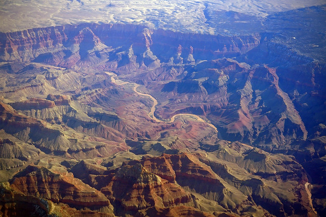 |
| Grand Canyon |
 |
| Grand Canyon |
 |
| Grand Canyon |
The Grand Canyon is so big you have several minutes of flying to get pictures should you be so fortunate to have good viewing conditions. As we leave the area, I see Lake Powell in the distance, the blue water snaking its way around all the red rocks around it. The perspective is almost other worldly – doesn’t seem like something real.
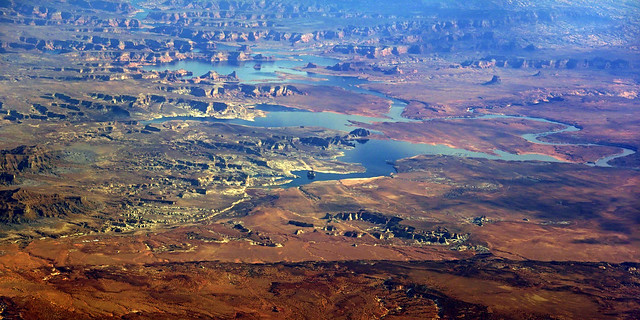 |
| Lake Powell |
The clouds thicken and eventually obscure the ground as we approach south of Salt Lake City. I’ve taken a lot of pictures with my little Sony camera and have less than a third of the charge left. Time to relax and think about how my trip went. I realize seeing all the landscape go by in the plane how little I have really seen, there is so much more to see out there. But then, will it all start looking the same after a while? But the only way to find out the answer to that question would be to go out and travel for, a while.
 |
| Mountains West of Alpine |
The clouds roll by and I think some more. It’s not like others have not traveled before me down the RV adventure path, but it isn’t like I can just pick up a job any old place in the USA should I need some more dosh. If only I could work remotely, traveling about. Retirement is still a bit too much of a stretch, or is it? Let me tell you as someone facing it, there is no magical line you cross where you suddenly know you have enough money to give up the daily bread. I will have to think on it some more – there is so much to see, and the body only stays good for so long. I don’t want to be one of those people that retires decrepit with all of the aches and pains of age and no gas left in the tank to explore about and have a few adventures before I shuffle off this mortal coil.
 |
| West Butte – Gold Butte of the Sweet Grass Hills |
The ground comes back into view just before we cross into Canada again. The Sweet Grass Hills in the distance look like islands rising out of a sea of prairie. Indeed, ecologically they are islands. The higher elevation is cooler and moister, allowing a different ecocline with trees and species not found for many kilometers around there.
 |
| Oldman River – North Lethbridge on the right |
I see familiar sights again, the Oldman River and Lethbridge, the true windy city of Alberta.
 |
| Travers Reservoir with many windmills |
The landscape is dotted with windmills. While we certainly can put out more windmills, it is a finite resource. Not to mention, most people don’t really want to be near those spinning blades and that low frequency rush the blades make in generating their power.
 |
| Carseland about half hour SE of Calgary |
Carseland is a small town just far enough away from Calgary to not really be blowing up much as another ‘burb of Calgary. But, it is just close enough that a little bit of growth has happened, just enough to keep this town going, where many more further out are withering with grain elevators having shut down long ago. Everything farming now is distilled into a few bigger towns and small cities, with large inland grain terminals and all the services a farmer could ever need. But the Tim Hortons does not have the same charm as the local coffee shop for farmers shoot’n the breeze.
 |
| Stoney and Deerfoot Interchange |
We circle around to the north. Me being on the right side of the plane, I get no view of the city going by, only as we get close to the runway to I get to see the larger ‘burb of Airdrie and cross the ring road interchange with Deerfoot. It ain’t a complex interchange by American standards, but it is starting to approach complex. Too bad we have so many interchanges in Calgary that need upgrades to this standard. Money, as always, is the issue to getting it done.
 |
| Calgary Airport Landing |
We land and taxi into the airport. The adventure is over, for now. I definitely have developed a taste for RV travel, and now need to figure out how I might do more of it some day. But in the meanwhile back to my normal life. The news I am hearing is more of the same, other than this new virus coming out of China that seems to be spreading out into the globe…
Authors note: This was written over the course of a year. I’m slow but I do get there eventually. But the style seems to morph a bit over time. Not spending another year to re-write the whole thing!

