

Las Tres Virgenes from a sunset lit lava field
Our stay at San Ignacio was only a one night thing. The square is way too noisy for a restful sleep. Not to mention, being parked beside the main tourist attraction for more than one night would definitely be pushing it. We moved on, with Carolyn having scouted out a location with great potential beside a lava field. Read on to see what we found there!

French toast with an egg addon
Our morning started with one last breakfast with the group leaving us. They were headed for campgrounds on the beach further south. We were headed for inland lava fields in the middle of nowhere. It was probably for the best we split off to pursue our individual interests. The breakfast at Isabel’s was french toast with an egg for me. I was of a bit of a delicate gut that morning. Who knows what set it off? I am eating a bunch of new to me foods. But overall, I’ve been of excellent digestive health down here. The egg I had was a proper egg, orange yolk with lots of flavor, not the pale yellow things in the USA and Canada, with little flavor by comparison. Had I known, I’d have ordered two eggs to enjoy.

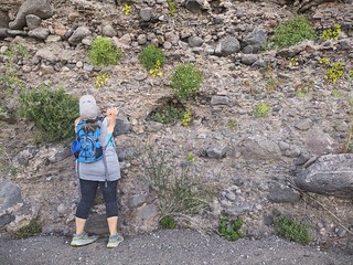
Cactus garden at the church
We didn’t have a long ways to go, so we explored San Ignacio a bit further in the quiet of the morning. The church gardens have a nice cactus display, all labeled with the names of the different cacti if you want to learn what is what. A long time ago, this would have been a food garden, as the remaining fruit trees gave hint to. You didn’t have time for ornamentals in the subsistence economy of way back when.

Very exact
Walking down the backstreets is illuminating in showing how this part of the world lives. There are horse pens, chickens, dogs everywhere. Houses are mixed with small businesses and government buildings like schools. While not planned out, it certainly is a lot more walkable for your basics. There is a much higher concentration of convenience stores and small grocers down here. Your house is much more likely to be within walking distance of basic necessities down here. However, do not wander the sidewalks with your head in the air. Safety standards down here are along the lines of “Safety? WTF is that?”
Not for any foot nevermind a high heel
You are expected to watch for hazards, be they open holes where utilities are under, or guy wires for poles going 45 degrees into the ground without any bright plastic tube covering them to make them easy to spot. Now, a lack of money is part of this, but it seems lack of resources also focuses the minds of the bureaucrats down here to provide only the absolute necessities. I could do with a bit less safety coddling in my part of the world.

Cactus fruit. Supposedly edible, tastes lemony.
Our walk done, we headed out to the spot that Carolyn was excited to share with us. While it is on iOverlander, it turns out to be a less used spot. Everyone wants to be on the beach out here. While a beach is great, solitude is great too. It’s very hard to get both here if you can’t 4×4 it down to the remote areas. We cross the spine of the Baja Peninsula again, this time coming over winding roads to drop onto a plain with Las Tres Virgenes looming ahead of us. This highway was better than the stretch between highway 12 and Guerrero Negro. By now we were at least somewhat comfortable with the narrow Highway 1.
 The warning signs for curves are few, however this part of Mexico has one unexpected warning feature you do not get in the States or Canada as far as I know. A warning to slow down, either for a curve or town is communicated with lines crossing the road. Sometimes the lines have bumps in them to really remind you with the “babum” sound that you should be slowing down here. The lines start out far apart, and gradually get closer together until the last bit sounds pretty much like “babum, babum-babumbabumbabum!” It’s an effective tool and should be ignored at your own peril. In town, they precede some of the speed bumps. Ignore these and you’ll likely scrape bottom on your RV. Some of these bumps are more like small curbs built across the road.

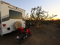
Camped beside the lava field
The flats had a stretch of improved Highway 1. We had noticed there were more of these as we proceeded south. Little towns like Santa Lucia were more frequent now, as well as the occasional stretch of cell service along the highway. We turn off at the road heading to the pin Carolyn had provided. The road was not too bad for a dirt road, but very windy and narrow. A larger RV would not have made it so it was a good thing we were down to three smaller rigs to get in here. We can see the lava field on the left – a jumble of rock rising about 10 meters to a chaotic field going on for kilometers.
A bit of shade even
We make it in around the sharp corners, trading a little paint on the bushes for access to this amazing area. We are right beside the lava, an ‘a‘ā. type flow, made up of rough rocks on the surface called clinkers. The rocks are aptly named, as they clink when they bump up against each other in the process of trying to climb a loose slope of them. The area is semi-forested, with a nice shade tree for me to sit under in the warm afternoons.

Trees among the rocks
There was a lot of walking around, as there was much to explore in the area. The lava is challenging to navigate across, I contented myself with climbing to the top and clambering only a short distance across the untravelled bits. What a wild scene on the lava though! It is a jumble of rock, uneven with holes and hills all about. What is most peculiar are the trees that have survived the lava to now flourish among the rocks.
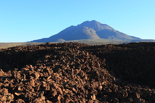
Lava with Las Tres Virgenes in the distance
I discovered that there was a faint trail running into the lava on a last light walk with That RV Over There. We climbed the start of the trail onto the lava, but it was too late in the day to do more than see that the trail went off into the lava field. A look at the googles aerial showed the trail crossing the lava flow to a large wash that might be interesting to explore. So our group decided to make a hike of it, heading out late in the morning to see what there was to see.
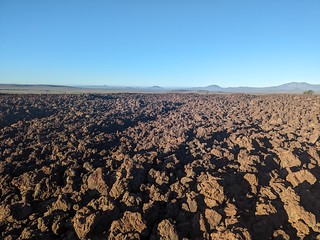
Lava to infinity
Walking among the lava is otherworldly. The rocks extend in a jumble to the horizon, with the volcano looming up in the distance. But it’s not all rocks. There is the occasional tree poking up, and even little islands of grasses with vast piles of rock separating them. The trail was faint, and only slightly less treacherous than the rocks to either side. It was certainly possible to take a fall, especially coming up or down the lava pile. That RV Over There covered the hike in the birthday video they did if you want to see just how bad it was.
 We made it off successfully, although not into the wash without Carolyn getting a bad handful of thorns. Literally. Don’t put your hand down anywhere without looking in these parts – you risk putting it down on something spiky for sure. We spent a half hour trying to pick some nasty thorns out. I was cursing my new first aid kit for not having tweezers. That has been fixed, the old kit did have this essential tool which has been moved over to the new kit along with a few other still usable items.

Plants hang off the gorge wall
The wash is more of a gorge at the point we climbed down into it, having carved a bit of canyon into the rock at the edge of the lava field. It made for a pretty scene with lava bordering the erosion and deposits of the wash. The trees and plants were lush, with many species new to us. Carolyn was in her happy place exploring a new environment. But the walking was tough. The wash started with benign gravel bars, but graduated to large rocks to avoid or scramble over. Then the gorge dropped over a cliff 10 meters straight down. The walls around were steep. It took a bit of scouting and some scrambling to find a way around and down to continue downstream.
Worshiping the hanging gardens
Water was also an issue. We had gotten a later start than expected, combined with a longer hike than expected. We were all rationing what water we had left, knowing it was still a ways back to our camp in the mid-day heat. There are some tricks to water conservation in the heat. Don’t overexert yourself. Stop for rests. Each stop should be in a shady spot if possible. Keep a clear head and make your way back by the safe most direct route. Following those tricks, we made it back with no issues, although I was pretty thirsty by the time I got back.

Meta photography
We had followed a loop, crossing the lava, following the gorge downstream, then climbing out of the gorge and following the lava field edge back to our camp. It had seemed a reasonable hike, but the gorge was more difficult than expected. Circle routes can do that to you; the whole trail is new so you don’t know how long it will take to get back as the trail back could have some surprises you have not seen yet. Good thing it was still February – the days were hot, but not the scorching heat of summer yet. The hike had been worth the thirst and injuries – the scenery was new and breathtaking to all of us.
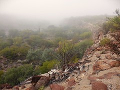
Misty gorge
There were other smaller hikes, one being an earlier morning walk in the foggy mist. That was a treat, you do not see fog that often in the desert.
It was great inhaling the air, which had a humid smell unlike anything I had ever smelled before. But it was good we had gotten an early start this time, as the fog burned off leaving us baking in the sun for the walk back our camp.
I also took the motorcycle for a ride to scout a potential boondocking spot, and pick up a few groceries.
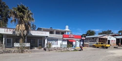
Santa Lucia commercial strip along Highway 1
Santa Lucia was only five minutes ride down the road from where we were camped so I went over to see what I could get for basic goods since we were all running low having stayed longer than expected by the lava flow. The one place that looked like a grocer was more of a restaurant / bakery called Panaderia Eben Ezer. I ended up buying one of their two litre jugs of milk, then contemplated the cake display. A bit of back and forth with the googles translate and I find out I’m looking at date and fig cakes, with one special cake I bought that was a mix of date, fig and coconut. The group agreed it was delicious. We had found that Mexican baked goods are less sweet and more flavorful than most American goods. They certainly suited my tastes.

Grass island
It turns out the only other store open was a “Six”, one of the two chains of convenience stores down here, the other being Oxxo. You will find they vary somewhat in size, with the smaller ones being mostly beer and a few snacks. This store was a little bigger. I picked up some interesting local snacks. The spicy dried mangos were amazing – I wish I could have brought back a few of these, just a wonderful start of sweet ending in a strong heat, but not so bad as to kill your taste buds. I managed to get a couple of other things on the list but it wasn’t a complete success. I’m not sure I found every store, in fact is quite possible some were closed that day. You buy what you can get on a particular day.

Where I turned around
My other ride was about half way to Santa Lucia turning north along a road that heads towards Las Tres Virgenes. I ended up finding a good boondocking spot just past an small active quarry. You’d be in quiet back there, it was a couple of miles off the main highway. I went further down the road, following it as it climbed a gully heading towards the Las Tres Virgenes. But I had to stop just as I could see the volcano clearly. I had not brought extra supplies in case I was stranded. The heat was enough that dehydration could get me if I had to walk too far to get help. So, back I went, having only partially explored the road.
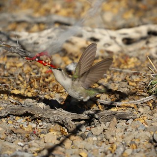
Only took three days of patient waiting at my camp to catch a photo
Checking the googles after, I see there are branches that go to the volcano, and some that go all the way to the Gulf of California coast – with a camping spot. But that would be a really long ride to get to the remote beach spot. I’m sure an RV would not make it – the road was already quite rough in places where I decided to turn around.
We packed up eventually with some sadness. It had been a great spot, although not quite all our own. A couple of RVs came in while we were there to camp at least out of sight of us. iOverlander spots do seem to get used in this part of Baja at least. We decided it was time to head for water again, on the Gulf of California side of the Baja peninsula. See you next time to find out how noisy a water spot can be!
