
 I had always been curious about what the Big Bend area north of Golden was like. It is dominated by Lake Kinbasket, a huge lake contained by the Mica Dam. There are some BC recreation sites up there to visit too, but no internet service to speak of. Now that I had Starlink, I could go exploring up there and remain connected to the rest of the world. Join me for two weeks of explorations up there.
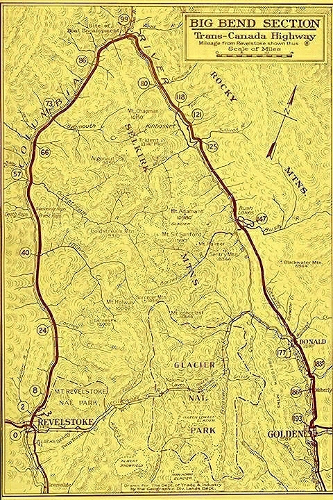
 I had returned to Didsbury to only leave a couple of days later heading out the same way I’d just been. But the previous adventure had been unplanned, so retracing my steps now that I was back on my planned adventure was acceptable. My plan was to visit an area my Dad had been to when he first was exploring BC: The Big Bend Highway, at least what was left of it. Part of the highway is under Kinbasket Lake, a reservoir that now fills a vast expanse of the Columbia River Valley and part of the Rocky Mountain Trench of BC.
Big Bend Highway in 1940 (source:Wikimedia) I was traveling as far as Mile 147 from Donald, where the highway enters the current lake.
The Big Bend Highway is so named as it traveled northwest from Golden up the Columbia Valley, turning with the Columbia River as it punches through the Selkirk Mountains heading back south to Revelstoke. Compare this to the direct route through the Rogers Pass which saved 174km and you can see why the opening of that route in 1962 was a big deal. Not only was it an upgrade to a nice paved road, but you saved five hours of travel on crappy gravel roads. One of the only bits of civilization you encountered along the way was “Boat Encampment” at the top of the bend. It is a historic junction point with travel in four directions from here going back to the fur trading days. It also had the one touristy thing up there at the time: Wooden Head.

Wooden Head in 1960
Wooden Head was an early proponent of road safety, telling you to “Drive Carefully, You’ll live to enjoy the scenery” I found out in researching what happened to this monument that it was saved from submersion by the lake – he now is situated near the Trans-Canada Highway in Revelstoke. My Dad traveled the Big Bend once in 1960, give or take a year, in his new 1959 Volkswagen Beetle. He did get a picture of the The Wooden Head, which I wondered about as the slide was just labeled “Big Bend”. I remember him saying the road was terrible. He never was much for traveling gravel roads if he could avoid them as he liked to keep his stuff looking nice and new. Now I know what happened to Wooden Head, thanks to the googles.

Grom on the Big Bend
The Big Bend Highway is now mostly flooded by Lake Revelstoke and Lake Kinbasket. I’m going to stick with ‘lake’ here even though these are both reservoirs whose water levels go up and down with the seasons. The largest stretch of remaining Big Bend Highway is between Donald, where the highway branches off from the Trans-Canada, to Bush Harbour Recreation Site on Lake Kinbasket, where the old highway disappears into the lake. The old road still exists because for this stretch it travelled along a side valley to the main Columbia River, staying higher and away from the river. Most of the rest of the Big Bend Highway is underwater after Bush Arm as the highway mostly followed the river valley bottom. It is an hour to drive up that stretch of gravel road, travelling through country that is mostly unchanged other than for some logging over the years.

1st Camp overlooking the arm
My first stop was Esplanade Bay Recreation Site, a site a few klicks south of where the Big Bend Highway enters Lake KinBasket. You head down a side road for several minutes, travelling down to the lake where there is a nice sheltered bay with a ten-ish site campground. Most of the sites are in the trees away from the water, but a few sites sit up overlooking a little arm of the lake, with one great lake shore site. The only disadvantage of the lake shore spot is people will be going right by your site on foot to access the lake – it is the only good spot to get to the lake. Being almost fall now, there was only one other person in the campground, of course they took this good spot.

2nd camp on the water
I contented myself with the best of the arm overlook spots, with just enough open sky for decent Starlink and a view of the lake. I could go down the steep slope to the water which looked liked a decent fishing spot. In a pinch, I could launch the kayak there too. But I didn’t have to make that call as next morning, my camping neighbor left. Normally I stay put once I park but this time it was definitely worth packing up again and moving over to the open camping spot by the lake. I had lots of sun and sky now so solar and Starlink were no longer an issue.

Close to the water, but everyone comes to the lake, to the right side of the photo.
It was summer weather in early fall, what a bonus here! I got the kayak out and into the water proto – you take calm water as soon as you can for it doesn’t take much wind to whip up an unpleasant chop on these big bodies of water. It turned out I was in for several days of mostly calm waters with lots of sun. I was loving it – summer weather on a lake, with no one around. Well, almost no one – it only took a day before someone else showed up and took the site I had vacated. But that is okay at this campground – the sites are well spaced and I couldn’t even see my neighbor. There would be a few people coming and going through the week, with the weekend seeing most of the better arm view spots taken up.


Fishing the Arm
With all the calm weather, it was ideal to try a bit of fishing. I didn’t have high hopes – these huge lakes can be difficult to find the fish in, but I was seeing a few surface rises that gave me hope. I fished around the campground, and ventured to the private campground that is by the next lake arm over from the rec site. It looks to be closed to the public, I suspect it is some sort of owner cooperative arrangement. I also checked out the arm the other campsites look out on, going all the way back to where a little creek comes in. I could see fish in the water and eventually managed to catch one. They turn out to be Squaw fish, not something you usually keep when there are trout to be had. I did see a school of what I’m pretty sure were Kokanee come cruising by, but no takers from those guys.
 I found a submerged island out to the southwest of the campground and fished around that too. It was calm enough to try a silver flatfish, something my Dad said was good for Lake Trout, if you could troll slow enough with it. To my surprise, I hooked into a nice Lake Trout pretty quickly trolling around the island with a bit of weight on to go deeper. It turned out to be my only fish, but it was a nice couple of pounds. I had some for dinner that night with my pork ribs – a surf and oink if you will. I’m sure if Dad had known about the fishing here he would have been tempted to bring his boat out, despite the gravel road. Fishing is not ideal from the Kayak, but at least it allows me to get out into the water a little further and explore around a bit. I’d have never gotten the Lake Trout without the Kayak.

Bush Harbour Rec Site
I traveled the last bit of the Big Bend with my Grom up to Bush Arm to check out that recreation site. I thought the highway went right into the water at the rec site, but it turns out that the highway actually enters a bit to the west and back, following Succour Creek into the water while the new road made a bend to right and stayed high until the rec site. Time has erased the road junction, but if you load Google Earth, you can trace the old highway into the water below the high water mark, if you select one of the historic images where the water level happens to be down.
 Bush Harbour Rec site is a bit confusing. The googles calls the site ‘Bush Arm’ which is incorrect, that is the next Rec site down the road, in the arm of the lake the site is named for. Bush Harbour is also confusing for what it looks like. There is an excellent boat ramp with docks for launching any size of boat. There are also a bunch of boats sitting near the ramp on trailers. There are a bunch of campsites that look to be occupied by the same owners year round. I chatted with a local who told me that the locals around there treat this site as ‘their space’ and just come up with their equipment in the spring and leave it there all season. Dragging trailers and boats an hour down a gravel road every weekend would suck, but they are abusing the system. It’s not like you can’t camp there – spots are available, but all the primo spots are permanently taken by the locals.

It’s called “Bush Harbour” googles.
I can see why the local enforcement doesn’t bother to enforce – it’s a local spot so you’d just be antagonising your neighbors, and it’s an hour just to get there to ticket people. So while you can come up here and camp, don’t expect to find a spot when it’s busy, and don’t ever expect to get a premium spot unless its the very beginning or end of the season. I was there in the latter part of September and they had the peninsula blocked off with trailers still perma-camped in there.

A boondocking spot past Bush Arm rec site, but there is some windy narrow road to share with logging trucks along the way
I went further down the Bush Arm, to the rec site of the same name. It’s a small site with each spot at least having a lake view. There is a small boat launch but it’s only useable by larger trailers when the water is high. There was one local camped in there who gave me the skinny on the area. I’d camp here, but only in the shoulder season when it’s not likely to be full. I wanted to go all the way to the end of Bush Arm, but the road gets a lot narrower and windy. While I’d have no problem with the Grom, I was scouting for spots for the RV. Knowing that there was active logging ahead with several logging trucks a day coming by, I decided further explorations that direction were not worth it at this time after making it about half way down the arm. Kinbasket is a big lake, this is one of the main arms, stretching 20 kilometers east from the main lake.

Help Lake from the camping spot
I also explored south going back down the Big Bend road with my Grom, exploring sidings along the way. Going along the road, there are four closely spaced lakes you pass by. From north to south they are Aid Lake, Help Lake, Comfort Lake, and a bit further separated, Blackwater Lake. They are all small lakes measuring about a kilometer long by a quarter klick wide. In between Aid Lake and Help Lake is Help Lake Recreation Site, which I actually stopped at on the way in. You would think that the campground would have easy access to the lake, but no – there is no trail to take you from the campground to the lake. You need to take the access road back to the Big Bend road and walk down that to get to the lake, a good half a kilometer of walking. The rec site has one sunny site, but it’s very unlevel, so I moved on down the road thinking correctly that I could do better around here.
 Now coming back, I noticed a little road turning off right at Help Lake, going down to the lake. I assumed it was an access point, but it turns out to be a little camping spot. There is a picnic table and fire ring, with a nice level spot for one RV. I suppose two could camp here if you parked end to end along the road, but that is it – the spot is small. You have about half sun, enough for solar and Starlink. It looked good enough that I decided this would be next week’s spot if nothing better popped up in my explorations. There was even a sign telling me this was “Scotty’s Crossing” although why it is called this I have no idea.

Susan Lake has a little boat launch and dock.
I continued south back down the Big Bend, turning off again at the access road to Susan Lake Recreation Site. The road goes a long ways in, climbing over a hill range dropping down to the lake just a little. It is your typical logging road, with no active logging in the area. Had the forecast been for warmer weather, I would have considered staying at this rec site, but things were starting to cool down. Plus, there was a day use person there fishing from a boat while I was there too. It’s not a big site, I think three spots in total, getting farther from the lake as they all are along the access road. I probably will come here at some point, but not in the middle of summer, it looks well enough used that the place might be full then.

The hill climb to Susan Lake
There are informal boondocking spots to be had along the way, I marked a few for potential future use, especially if I want to go in here during the summer holiday season. That will be the time I’d be up a logging road with no water nearby camped along a disused siding. Speaking of disused, I should note that if you are looking at a googles map of Susan Lake and see Jeb Lake Recreation Site to the north, note that the road is is quite overgrown. I wouldn’t take an RV in there, in fact I didn’t bother going all the way there with the Grom as I’d have been pushing branches and dealing with rough road for several kilometers.

I was *right* on the water at Help Lake
I decided to return to the Big Bend area for a second week following a resupply in Golden. Help Lake ended up being my spot, a lake on the other end of the spectrum for size. Now I was on water that was ideal for my Kayak, being able to paddle all over the little lake looking for the fish. This was a great spot other than being right by the Big Bend road. There was a bit of a tree screen from the road for privacy, but I was close enough that the road dust could blow on me if the wind was the right direction as a vehicle passed by. Fortunately, the road is not too busy. There are a few logging trucks each day, and the occasional RV/boat hauler going by in the shoulder season here.

One minnow, not worth keeping!
But being so close to the water made up for it. I could literally cast from my door if I wanted, which I did. Help Lake was not very helpful at first getting me any fish. I cast in the evening getting several bites but never hauling anything in. Next day, this continued in the Kayak, with me not hooking anything well enough to get it to the boat. I finally managed to haul in a little minnow in the evening – looked to be a tiny Rainbow Trout. I felt like the lake was taunting my fishing skills, I knew there were bigger fish to be had so I actually got motivated to fish a long spell and find these fish.
 I took advantage of my Kayak to fish some of the shallow grassy water where the creek came into the lake. I could see fish rising in there occasionally. That strategy finally netted me some larger Eastern Brook Trout, who where congregated around the creek as it was spawning season for them. I caught four fish in about an hour – they were hungry there. I ended up throwing back a smaller one and kept three. Two were eaten for dinner. These were not as tasty as the Lake Trout, probably being under a bit of stress during the spawn which can put the meat off. It was still good, 7/10 fish rather than 10/10 type difference. Overall, I was very happy with my fishing experience here. I did see one couple fishing on Comfort Lake. Judging by the number of fish I could see rising, it would be a similar matter of getting the fish to bite, finding fish is less of a problem as there isn’t a ton of fishing pressure on these lakes.


 When I had explored through the area previously, I had noticed a trail nearby the Help Lake rec site. I thought it might be a way to the lake, so I took it a short distance. It turned out to head up the hill, not towards the lake so I turned back. Now that I was camped nearby, I decided to ride the motorcycle over and hike up this trail to see where it might go. The trail was maintained, and showed signs of usage. It had to go somewhere I figured. It turns out that the trail climbs up the hill to some cliffs that rock climbers use. There was all sorts of equipment around for climbing, like anchors and ropes left in the rocks. They even made signs out of flat rocks marking the different routes you could climb up the rocks. The view was not great, the trees around me obscured things. I was not going to borrow a rope and haul myself straight up to get a better view, I’ll leave that to the crazy rock climbers.

Aid Lake to the left, Help Lake to the right

Note the rope going over the edge of the cliff
Rather, I took the logging road up the following day, that did a zig zag up the hill, coming up at behind the clifftops and terminating at an area that looks to have been logged in the last few years. Now I just had a little bushwacking to get to the clifftop. It took me bit of exploring, but I eventually found the anchors for the top of the cliff. My view here was much better, being able to see a good part of the side valley the Big Bend road goes through here, along with the string of lakes.

My camping spot from above
I even found an unexpected rock – a really nice finger of quartz crystal. There was a bit of quartz around the area, but nothing like this. It was in the dirt near the cliff top, disturbed by some uprooted trees. I’m still wondering now if this is a real rock from the area or a lost healing crystal from one of the cliff climbers. That mystery will remain unsolved. I was glad I had gotten up to this viewpoint earlier in the week, as the weather was turning and this was one of the last nice sunny warm days before a bit of cooler wet fall weather came in.

Leaving Help Lake
The storm didn’t last long. I did manage to get out on the lake again, in fact my best fishing was while I sneaked out between weather systems to try my luck. My Dad would have said that that changing weather makes for good fishing, perhaps he is right about that one. I had spent two weeks exploring this area of the Big Bend. For the most part the weather had been great – I had a lot of days watching the sun go down over the hills as I sat by the lake. But it was time to get on south – I was planning a loop trip that would take me back to Calgary one more time this year. Voting was in the latter part of October, so I’d be back for that. In the meanwhile, I was headed south along the Rocky Mountain Trench to explore some camping spots that might be empty now that fall was in full swing. Join me next time to see what is empty, and what is not!
