

Returning to the rig from my Sunrise view of the Grand Canyon, I pack three bottles of water. I also pack my three heavy lenses, lunch, rain gear, map, bean bag tripod. Ugh, this pack is heavy. Ditch a lens? But it’s the Grand Canyon… Although my 70-200 F4 is a top notch lens, I’ve got a 18-135, do I really want to schlep this thing around for the little extra reach? But it’s the Grand Canyon! When am I ever going to be among this kind of grandeur again? The lens stays, we will see how much I like it when I’m hiking back up the canyon carrying all this gear.
I decided to walk from Mather Campground to my chosen trail head: the Kabab Trail that follows the Cedar Ridge down into the Grand Canyon.
Walking allows me to explore another part of the rim of the Grand Canyon and it is fairly quiet. The standard drop off points on the bus routes are where all the people are.
The Park Service has some signs up talking about this area I passed. I’m going by memory, so take this as approximate. The area had been burned by a man-made fire about 15 years ago. Evidently, the fire got out of control, making it all the way to the rim here and threatening Grand Canyon Village. If I recall, unexpected winds sent the fire off the expected burn path. But you can see here, there are plants you do not see in the mature forest areas. Fire is part of the history of the area – the previous attempts to suppress all fires changed the landscape as much as any other man made thing. But prescribed burns are tricky – mother nature thwarts the best laid plans sometimes.
I have picked the Kaibab Trail in part because the advice I got from the Ranger that the trail was less snow covered. Bright Angel Trail had a recommendation of having crampons for descending the icy bits. I was hoping less snow would mean no crampons required, or this would turn into a short hike indeed! Looking ahead at the walls of the canyon partially covered in snow, I was not sure at this point if I would be able to make it down the trail or not.
I arrive at the Kaibab Trail head. I do see some snow and ice on the trail, but it looks like enough feet have been over this to track some grit along on top of the trail. Plus there are no signs advising of crampon use – I should be good to go down!

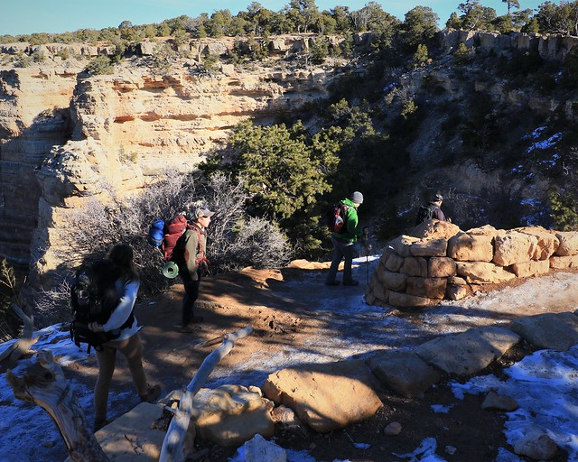
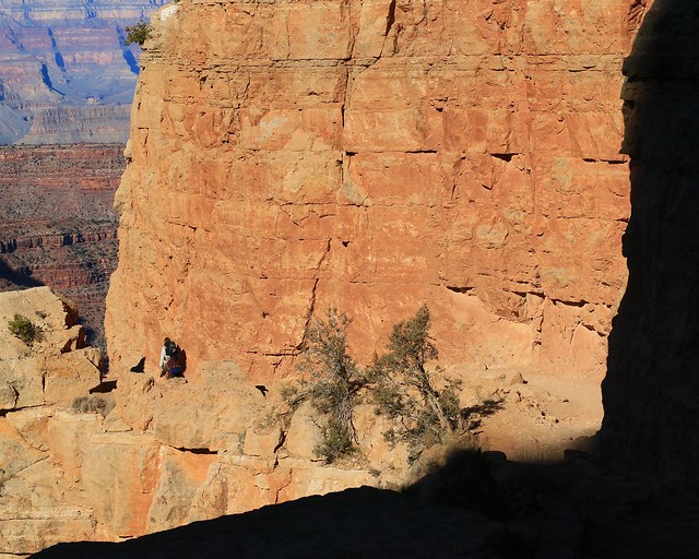
While I had seen the path in the distance approaching it along the rim, I had not seen the beginning of the path, as it goes down a cliff not visible from the rim. You can see, the path winds more down than across, winding back on itself to drop down the cliff. There are extensive retaining walls and cliff walls carved out to squeeze a path in on the cliff. The ice is slippery in places too. This is not a place to be if you have fear of heights and a less than sure step.
I see people edging their way down gingerly, perhaps finding this a bit more challenging than expected. My shoes are of a good walking kind, but have no spikes, so I have to tread with caution over the slipperiest bits. For me, this path is like a highway – no danger of falling over the edge, but a fall down and scraping myself up or even breaking a bone is a possibility. So I pass the meeker walkers, but the full out hikers pass me at times. The speed you go at should match your ability and gear.

I get down this intimidating switchback onto the much more benign looking ledge continuing down. Looking back, I can see this first switchback does drop pretty much straight down the cliff 200 feet to start your hike. I am glad to see I am coming out of the shade into the sun as well, so the ice is being replaced by mud where there is moisture. Mud I can handle – I’m feeling more confident of making it as far down as I might want to go now.
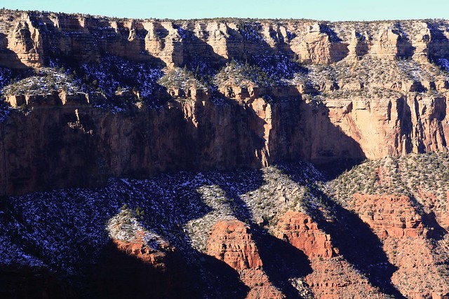
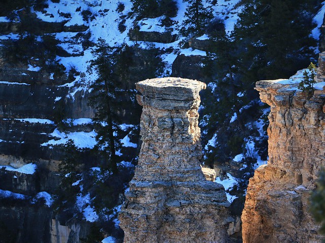
I can look up for the first time at the cliff across from me, from where I had been earlier looking at the bit of trail I was on now. The snow adds a nice touch, but I’m glad enough of it has melted to make my hike down here without crampons possible today.

I see the Grand Canyon from another perspective now – I’m in it! But only just a tiny little ways so far, all of 300 feet of 4800 feet to the river. I have been warned of the dangers of trying to go down to the river and climb back up to the rim in a day. Now, I need to figure out how far down I can go and still make it back up. I’m used to doing the hard part of the day first, hiking up the mountain.
Being out in the sun is nice, but it reminds me of the other danger hiking down. It gets warmer as you go down, and you consume more water sweating. Coming back up, you’d better have most of your water still because that is when you will really use it up. This being winter, is less of an issue, but not a non-issue. I’ve packed three pints of water assuming I will use at least two – the temperatures may not be scorching, but the heat of the sun and the rocks bouncing back at you adds enough to make you sweat.
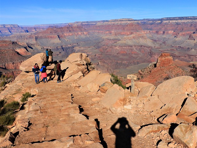
I arrive at the first view point, 600 feet down. “Ooh Aah” point may be a funny name, but the views do inspire some admiring ohms. In the scale of difficulty, this is considered “moderate” by the Parks Service. I would consider it easy for me, no problem going to the next level down, “Cedar Ridge”, considered “difficult” by the Parks Service. The last level down and the longest recommended for a day hike is “Skeleton Point”, considered to be a “very difficult” day hike by the Parks Service. Considering my subtraction of one level of difficulty, Skeleton Point is what I have to consider if I will go to or not, Cedar Ridge will be no problem at all for me.

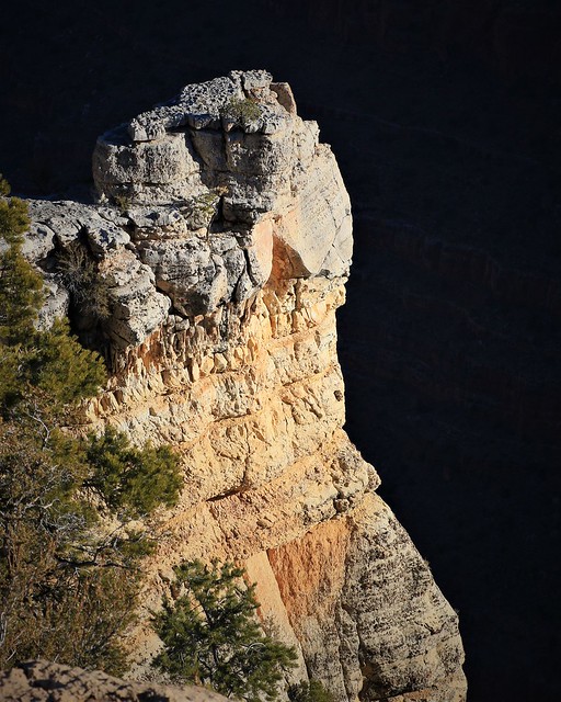
I can see Cedar Ridge below me, looking far down, but at least a comprehensible distance. The further reaches still seem too abstract. I can see I am at the bottom of the yellow rock strata. Looking across the Grand Canyon, I see the border of that same rock, and how little distance I have come down compared to the whole. But we will continue on!

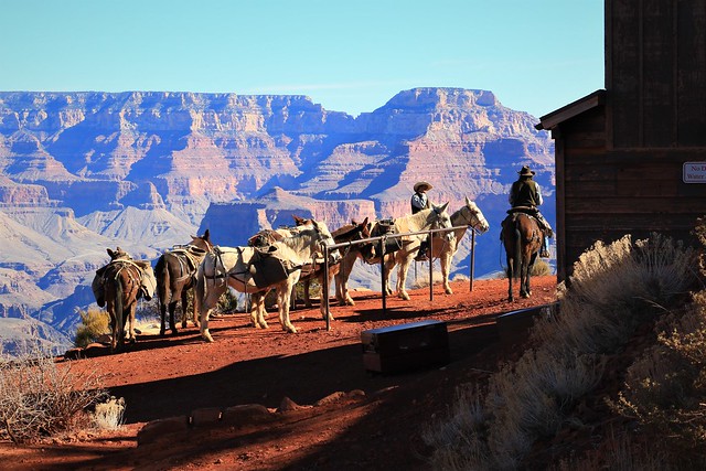
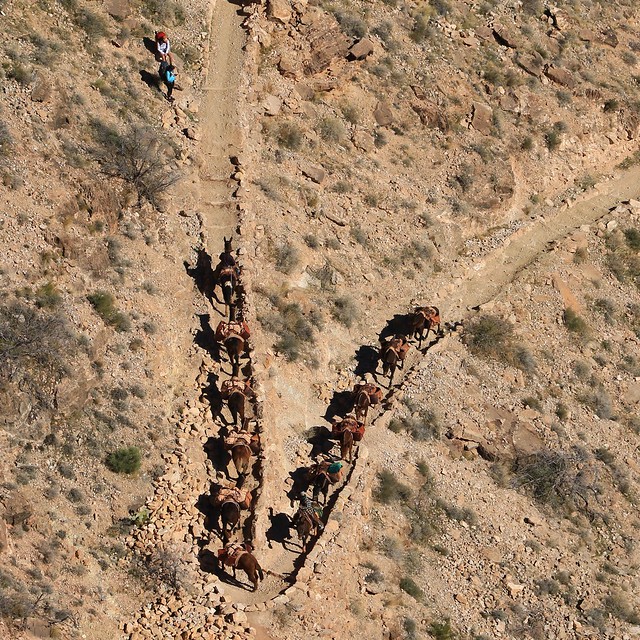
I am interrupted in my viewing by a chorus of clomping, stomping and shuffling sounds coming up behind me. I turn to see a mule train coming down the trail. What good luck! I am in a good place to photograph and I have good light too. I position myself in the best spot possible while staying out of the way. Sometimes, you just get lucky and are in the right place at the right time to get a photo. Not to mention, seeing a mule train pass is just great bonus to Grand Canyon hiking experience. I marvel at the sure footed nature of the mules – they seem to plod down the trail like I’d saunter down beach – no big deal on the trail here for them here.

The Mules go around the corner exactly like a train would, each following after another like on a train track. They recede down the trail, kicking up dirt with each hoof beat. It dawns on me that the mules have a lot to do with the trail not being sheer ice. Between their poop and their shoes scuffing up the ice, there is added traction thanks to these animals going up and down the trail.
I follow after the mules, but they quickly disappear around a corner. The trail drops another 600 feet to the ridge, winding its way back and forth to drop you on a little flat area before continuing down the side of the ridge. Every corner, I am surprised at how far down it still is to go, but eventually I see I am getting closer to my next destination.

The mules however have already arrived below! They certainly move a lot faster than I do, even allowing for my regular stops taking photos. I have a new appreciation for why this is the transportation of choice for cargo coming down these steep and narrow trails.

After winding several more switchbacks than I expected, I see I am finally on the last few steps down to the ridge. The distance down is deceptive – from above it seemed like I would be down in only a few minutes, but only the mules made it in that time.

I arrive at the ridge. I see the red soil devoid of any vegetation. I assume between the people and the mules tramping about nothing is left growing in what is a marginal growing environment to start with. There are a fair number of people milling about. This level of trail has not really thinned out the number of people – most people of reasonable health can make it down here and back, especially in the winter when you don’t have blistering heat to contend with. However, a lot of people choose to make this the farthest down they will go so the path starts to have a lot fewer people below this point.
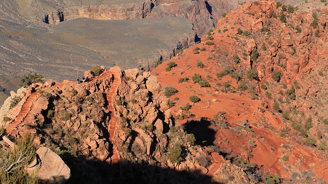
I see the the ranch hands are preparing to take the mules off on the next leg of their journey – not down the trail but off a side trail, where that goes to I do not know. But I must consider my journey next too, do I continue down to Skeleton Point? I decide first to walk further down the ridge to get a good photo of O’Neill Butte. Getting up closer to it and photographing it with the blue sky behind makes for a much more dramatic photo that against the dull red of the distant canyon wall when shooting from farther away.
I walk down the path others have tread before, then beyond where most tread, not being quite close and low enough to shoot up into the blue sky. After clambering up and down some rocks, I get the angle I want. Extra effort yields the shot at the end. I head back to where the trail turns off to head down the ridge. I’m feeling pretty good still and it is early – I think I will try for Skeleton Point. I can always turn back early if it turns out to be too much.

The trail starts down and switch backs to drop quickly. But then it levels out to some extent, having to cross over the lower part of Cedar Ridge to pass under O’Neill Butte to the west. The level walking is certainly nice after constantly pounding on the legs pushing down the trail.

Finally, over a thousand feet down, one feels like you are truly in the canyon, you actually look up to the rim now, but still way down to the canyon below.
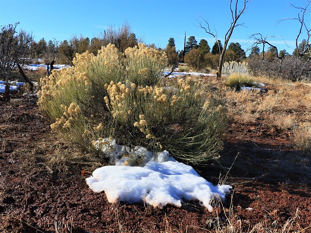
I notice the vegetation is changing, there are desert plants again, and things are unexpectedly greener. But then I remember, it is warmer down here, not as cold at night. I’m actually looking at the first signs of spring in the desert down here, this late January in the Grand Canyon.
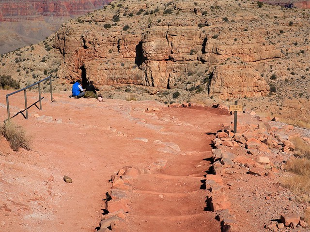
After walking further down some gently down sloping red path, I arrive at Skeleton Point, where there are only two people to share the view with, and lots of grassy areas I can mosey off into to get a little private spot for lunch. Yes, coming this far was certainly worth it to get away from the people. I look over the edge of the point and see the trail drops steeply switch backing again downwards to the flatter plains I see at around four thousand feet. That pretty much decides it for me, lunch will be at 5100 feet, looking down at the trail continuing below me. I can explore around here a bit and take my time, rather than risking going further down, and then having to immediately turn around and head back up. One must take some time to properly enjoy being in the Grand Canyon!

I have a nice view at my chosen lunch spot, a couple of minutes down a faint side trail. I can see Bright Angel Creek, and just make out the little camping spots, still three thousand feet below me. Having walked down two thousand feet, I now have an idea what it would be to walk down the whole way – you need to walk it to appreciate the size of the Grand Canyon! But even from my high vantage, the canyon drops off so steeply below me that I can still not see the Colorado River below me.
I do see another mule train, coming up the switchbacks to Skeleton Point. It is fascinating to watch them from below, realizing that the word “train” dates back to this kind of animal train rather than the steel car train we think of today with that word.

I also see peaks across from me, I am just low enough that the highest points in the Grand Canyon are above me. You can see the trees of the North Rim behind these peaks – doesn’t seem that I am that far down, but I have descended roughly two fifths of the way down. I’m okay with that, it is enough to get away from the people and down enough that you feel you are in the canyon. Finishing my lunch, I decide to wander around the area a bit and see what other views I might get. I’m not going down any further though, I’m staying at the top of Skeleton Point for the eventual walk back up to the top.

In my first wanderings immediately around my lunch site I spot an actual shell fossil, something I had not seen yet on my desert adventure. It is firmly embedded in the rock here, so no temptation for anyone else wandering across it to just pocket a souvenir.

I wander back to the trail, and cross, following a ridge to what looks like it may be a good viewpoint. Finally, I spot the Colorado River – closer but still a long ways away.
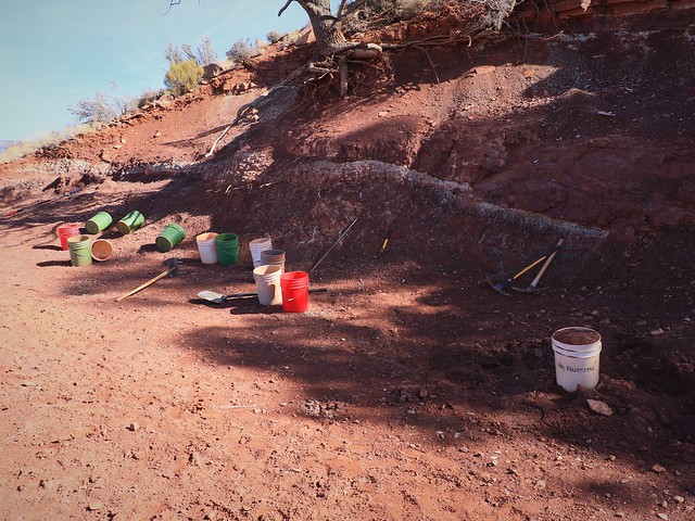
Wandering back up and across the ridge to hit the trail, I come across something unexpected. This is a mining camp! But wait, there is something off about this little quarry. For one, miners would not leave their tools lying about. Nor would they use new shiny four gallon buckets. Nor would everything be so neat. It dawns on me, I am looking at a “mining site” for tourists. Come to the Grand Canyon and experience a bit of it’s history – be a miner like the prospectors of old! I can’t say for certain that is what is going on here, but it is the only thing that makes sense. I’m also wondering, what is that vein the tourists are mining?
It is time to begin the long climb up again. I’m feeling pretty good, but soon the slog up starts to wear on me. I’m definitely drinking more, I’m now on bottle 2/3, and draining it fast. Now the sun is not so nice, but at least I’m going up the east side of O’Neill Butte, so I am often shielded from the sun. Once I hit Cedar Ridge, I will be in the full sun, see how warm we get then.

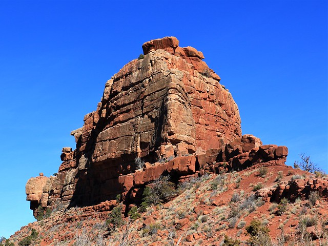
The mid day sun makes for flat light and dull colors. But there is still the occasional interesting subject, like this one I dubbed “Dice Rock”. It just needs some white pips on it to be the biggest Dice out there.

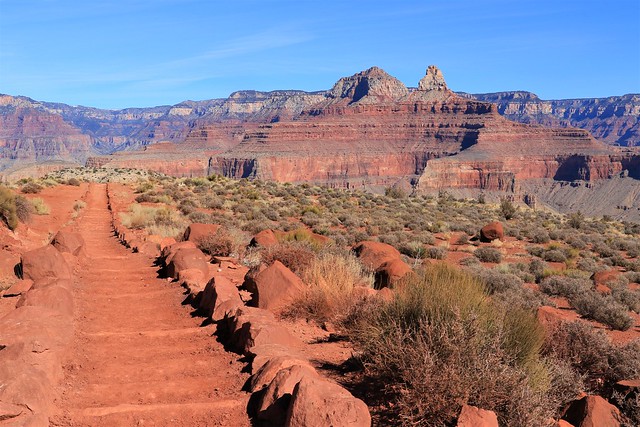
There is the occasional angle that works in the mid day light, like O’Neill Butte here from another side that would have been dark in the morning. The red is so vibrant that even in the mid day light it still looks impressive.

Up I go, past Cedar Ridge. I’m walking a lot more now and photographing less. I’m into my third and last bottle of water now, but I’m not that worried – I know the top is not that far and it is not that hot up here even in the sun. The knee is twinging a bit though – not liking that at all!

Up I go, switch backs in the snow again. I’m going slow and steady – no hurry here, lots of time to get back. No races to be won getting to the top sooner. But it is a good workout. I’ve burned through breakfast and lunch by now, time for a granola bar and a little bit of energy to get me up the last bit!
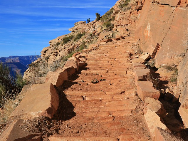
The rocks turn to yellow. I see yellow cobblestones in places on the path too – nice and durable for mule and steps, but a bit on the slippery side if some mud coating is on them. Up ahead, I see the last switch backs, straight up the cliff again. Slow slog up them, the ice never melts here as the sun never shines against this cliff at this time of year. A few more stops, but then I’m back at the top! I decide that I don’t really need to walk the rim again back to my RV, been here done that, plus 2000 feet up and down today! I’m waiting for the bus for a ride back to Grand Canyon Village and a short walk back to the RV.

But I am distracted by one last thing before my adventure ends. I am dropped off in front of the Yavapai Lodge, where I see the sign for “Tavern”. Hmmm. I am thirsty, let’s see what they have for beer. “Piehole Porter” sounds divine. I drink to my grand adventure today.

I decide another beer is in order, since they had TWO beers I could not pick between. An “Upslope Brown Ale” is surprisingly dark, and also quite tasty. Oh, did you see who was in the tavern crowd? Spot the two mule wranglers at the bar – these were the ones who passed me going down. It seemed I was in good company celebrating my day in the Grand Canyon.
