

Kelso station sign
I was heading north on my own again, with a long travel day ahead of me. My goal was to make it back to Mesquite, Nevada where I had previously scouted out some cool potential boondocking spots. I expected to find a good spot, one even had a great view of the Virgin River valley. I did not expect to run across another familiar landmark I had seen only in my internet travels. Read on to see what I found!
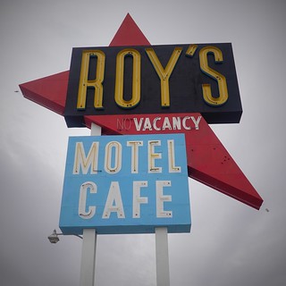 My route took me north on route 62 past 29 Palms. I remembered the good times we had eating out and visiting there. From there, the googles took me north along a back road. There was not much out here beyond a salt mine. But there was also not much traffic. Driving through the desert being able to see miles with no cars is relaxing. However, I was not quite so relaxed as to not check and make sure the googles were not sending me down some cart path or off a cliff. But all was well, I could see this did indeed connect as a paved backroad. I came back to slightly more civilized country on Route 66, joining it at the town of Amboy. Driving through what little there was of the town, I see a gas station ahead that I immediately recognize, having seen it many times on the internet at Ken Rockwell’s photography web site. He does a regular photo tour where Roy’s gas station is one of the stops, I knew that sign right away from his photos. This was worth a stop, even with my long day of driving still mostly ahead of me. I snapped a few pictures but wasn’t expecting anything special. Middle of the day flat clouds made for flat color pictures. The best I could do was go for dark and gloomy in my post processing. But at least I had seen one of the places Ken goes to regularly with his photo group tours.

Kelso station
I resumed my journey, turning north again from Route 66 down another back road that would take me north of I40, and into Mojave National Preserve. It had some pretty scenery, I could see a few roads going off that might have some boondocking potential. I’d have to see about coming back through some time and checking it out for a stay. The Preserve is large. I stopped in the middle of it for lunch, at a little railroad town called Kelso. There is a grand old station there, way bigger than you would expect for a small town in the middle of nowhere. The station it turns out was at a major rail exchange, where locomotives had to be added to have trains make the steep grade past the station. The station was built more to serve incoming and exiting employees of the railroad. But modern railways don’t need the services anymore and now Kelso is just a minor town in the middle of Mojave National Preserve. I will say that the stop there is very nice for having water, bathrooms and garbage disposal, always useful things travelling. Unfortunately, the station was not open at the time to allow me to more than look through the windows at the inside.

A road marker on the old abandoned Route 91 near Riverside
I proceeded north from Kelso. Mojave National Preserve is huge, it was some time until I left it and joined Interstate 15 just south of the California – Nevada border. It was quite obvious when I entered Nevada. The town of Primm sits on the Nevada side of the border, hosting several casinos for those that would rather stop and gamble as soon as possible rather than driving the short distance to Las Vegas. Vegas didn’t even merit a stop from me – I was only interested in cheap gas. I had enough gas to get me past the city to the Moapa Paiute Travel Plaza, a truck stop in the native reserve of the same name that is much less hassle to get to from the Interstate. Someday I might hit Vegas for a show, but the city overall doesn’t appeal to me, like most cities.
My boondocking plans involved a couple of potential spots. I turned off at a truck pull out and headed to my first preferred spot. It overlooked the Virgin River Valley. I was hoping there would me no one there unlike when I scouted it in the fall coming down. The road there is a decent gravel backroad that meets with a section of the old Route 91, still paved and in good shape other than the encroaching shrubs here and there. However, there is one section where a culvert has been removed and you need to detour into the wash. That one bit is what is keeping large rigs out of the area, you need just a bit more clearance to get through the wash. There are big rocks in the wash too, you need to pick your path carefully to not get stuck between some large rocks.
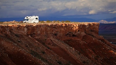
Camping cliffside
I made it through without issue, having decided to try it as I saw no one ahead where I thought the boondocking spot was. Sure enough, I arrive and see I have the whole area to myself. There is one good spot a couple of RVs could squeeze in close to the road, and if you go down the faint trail there are a few spots further down all overlooking the Virgin River Valley. I parked with my back window pointing to the best view – probably the most expansive view I have had yet in my travels so far.
Virgin River Valley
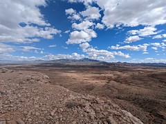
I was happy – the first best spot I had hoped to get worked out for me. In fact, the spot was so good I decided to stay most of my remaining time here. I was now far enough north that I could get back to Canada in a couple of long days drive. I was up on the flat plain, far enough from Interstate 15 that is was not more than a dull hum in the distance if the wind blew the right direction.

A few Joshua trees here NE of Vegas

Aircraft, not alien beacon
The one obvious thing you could see from the Interstate was a strange looking circular building. As there is a pull off near it, I’m sure people regularly drive or walk out the half a kilometer to this curiosity. A little bit of googling tells me this is a aircraft navigation signal facility. These are the way airplanes navigated without being able to see their surroundings prior to GPS. The system is slowly being paired back, but being kept at a minimally functional level as a backup to GPS navigation for planes. Some people in the google reviews of this place (now deleted) are convinced it’s some sort of alien beacon or religious marker. At least beacon is the right idea, even if people have overactive imaginations and jump to aliens right away.
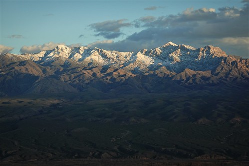
Late season snow on the Virgin Mountains
I enjoyed the views walking around the cliff drop off, which extended for kilometers if you cared to follow the meandering cliffs. But my time was running out, it really was time to get back to Canada. My plan was to head for Kootenay Lake, hoping that the snow would at least be melted down by the lake by what was now late March. Join me next time on my dash north and see how that turned out!
Current update: I’m writing this in the fall after a busy summer in Alberta. Updating didn’t happen. This post was written over two months of half starts. I should be doing better now as I’m out camping again with rainy days to catch up more. But like the weather, you’ll see it when it happens!
