
 My week in Mesquite ended up being more interesting than I expected, like finding the old Route 91. OK, that was interesting to *me*, being a bit of a map and transportation nerd, but hopefully those of you who read my previous entry didn’t fall asleep because I found out more stuff in my continued research! Plus there are some motorcycle adventures if you read past my old road obsession!
It turns out the State of Nevada has a section with digitized copies of all of their official highway maps. Looking at their oldest 1919 map I can see the road curving away from the river. The scale leaves you a little short on detail, but that would be the last confirmed usage, with the 1922 map showing the new alignment. Also, as I suspected, the original alignment went further down the Virgin river along what is now the access to the Gold Butte Area. I drove down this, on what is probably the oldest usable asphalt I have ever driven on. It gets very pebbly as it wears down. I wonder if it is still the original 1920’s pavement? The crossing of the Virgin River was at St. Thomas (now a ghost town). The road then made a line to Las Vegas, probably following what is now the Valley of Fire Highway. So the alignment I was walking along had last been used pretty close to 100 years ago, no wonder there was so little pavement left!

A potential boondocking spot along Gold Butte Road.
My ride down the Gold Butte road was on the Grom, I was out exploring a bit for new boondocking spots. That same ride found me the old stretch of Route 91 that is in much better shape, with boondocking spots along it. My next stay in the area will probably be along that stretch – it was a lot cleaner with some great views if I dare go up the cliffside part of the highway a bit. The Grom got a lot of use this week – there were quite a few interesting sights to go see nearby.

Riverside entrance
I contented myself with sticking to looking for boondocking, and one “ghost town” as Riverside is referred to on the googles map. One of the local reviewers of the area says this was actually a service station and motel, which I’m inclined to believe. The buildings are all the same small size and style (from what you can see through the graffiti). Wikipedia has a little bit of info to add as well.
 In fact the graffiti is one of the more interesting bits to see out of what remains of the structures. There are quite a few cabins here. If you look at the old maps, this would have been a good stopping point on the way to Vegas. You have trees, the Virgin River and the cliffs behind you that you will climb on the way out of the valley continuing your journey towards Las Vegas. But Interstate 15 opening in the 1950’s would have killed this stop – while it is not far away from the Interstate, it is a detour you need to seek out, rather than a pull out off the highway. Towns and businesses across America died by being bypassed by the Interstates, but you can’t have progress without killing off a few vestigial organs.
 You may be wondering about the “People” sign I used as a teaser picture in my last post. That is at the entrance to this former gas station / motel. But why it is there? That is another mystery that leads me to have the category of ‘WhoKnows?’ ticked off for this post. I did find another take on Riverside at Treasures in America, not a bad read and judging from the photos, taken before a lot of the graffiti was added.
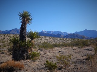
Start of the Yuccas with the Virgin Mountains in the distance

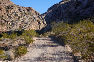
Rough road going back a different road
I also took the Grom out to the Virgin Mountains, to check out a watering hole and some cattle corrals. The mesa you ride up slopes gently up towards the hills, with occasional gullies breaking up the flats. Most of the time you ride up on the flats, with a view looking back all the way to Interstate 15, five miles away from you. The roads varied from the rough less used road I took back to a pretty good road an RV could travel on. While the Grom can handle the rough stuff pretty well, I appreciate the sections of smoother road for being able to ride in comfort putting on the miles a bit quicker. I’m no speed demon, but I’d like to go a little faster than the 10kph I could manage on the rough stuff.

 Arriving at the cow corral at the edge of the hills, I see cows are present. What I don’t see is water. Seems strange there is no water near the feed? The road continues past the corral, heading for a canyon. The first passage is not bad, coming out in a narrow windy valley that narrows to a second canyon further up.
 Now this canyon is narrow – the water would fill the whole area as soon as there was any significant rain. I leave my bike at the end of the sandy bit, where a rocky steep bit is just a bit too challenging for my new motorcycle skills. I see from my top0 map that I am quite close to the water hole. A little walk today wouldn’t hurt me. The valley opens up a bit as you get higher here. While I have been riding up, there has been a progression of vegetation. The lower areas have Mesquite trees near water. As you climb, the Creosote bushes start to be interspersed with Yucca trees. Up here, I am just starting to see a few Cedars above me. As I found out later, this pattern is typical of the vegetation progression with altitude up here.
 The watering hole was a little difficult to find, but there was water up here, even running down a little stream before petering out to nothing. So the cows have to come up here for a drink? I passed other tanks and de-commissioned watering structures – perhaps the cows have something closer I did not see. But the area with the water was a nice oasis, with big shade trees and vegetation taking advantage of the constant water source.

Cow died falling off the end of the culvert
I was dividing my time between motorcycling and hiking while in the Mesquite area. I was not far from the State road 170, which kept course parallel to the Virgin River. I hiked back down my access road, crossing the 170 then headed down a cattle trail that went to the river. Following the cow trails to the water is a trail tip for you. The river side is green with trees and high scrub all over, in fact you can’t walk some places with the thick vegetation. One day, on a second hike to the river, I decided to check out the culvert under the 170, and travel that way to the river. It was not to be, as soon as I got to the end of the culvert, I could see erosion had carved away a good five meters down, leaving a cliff that some unfortunate cow had not seen in time, and gone falling off to their death. I’m sure this kind of stuff pisses off the ranchers in the area. The road works should either barricade the culvert entrance, or backfill the drop off on the other side. But it was a good reminder, you don’t go walking through cattle country without watching the path ahead of you.

Bulldozer building levee
My walk along the Virgin River encountered fresh bulldozer tracks which I followed down the the actual bulldozer. It was parked for the weekend, where it had left off building a new levee protecting the cliff from being eroded by the river. I have no idea why they are protecting the cliff – the only thing on top is some boondocking spots, of which I did finally find some that I might be able to visit with the RV. It’s not ideal – you still are pretty visible from the highway everywhere, but you can get a river view at least. Any road going down to the river was just a little too much for an RV. Perhaps the bulldozer will improve the access on the way out, one can hope!

Mesquite leaves
My adventures for the week had come to an end. It had been a week of some variety, with mountains and valleys to hike and motorcycle to. I had not even had time to try a ride back to town with the Grom to get a little more street practice with the motorcycle. But there should be plenty time for that in my southern travels. See you next time, in the Joshua trees west of Searchlight, Nevada!
