

Stick figure Cholla
I had a slightly longer drive to my next destination, as I wanted to avoid the Las Vegas area for boondocking entirely. I had scouted out a road and trailhead east of Searchlight, Nevada with the googles aerial. It had some promising looking spots on BLM land. But I did not expect the forest I encountered upon arriving there. I certainly didn’t mind this surprise!

Vegas glow frames the RV
Someday, I might brave Las Vegas to see a few of its sights. There isn’t much I’m interested in, but I like the bright lights. Perhaps I’d see a show if I went there. So my stop in Vegas was for grocery shopping only, certainly one of the more boring things you can do in Vegas. I made my way south out of the city, seeing flat lands off to my right. It was a dried up lake, with some campers and vehicles speeding across the flats. I could camp here if I had to, but normally this sort of site is not for me. Not to mention, I wanted to get a good hour outside of Vegas to avoid the city spillover into the country.

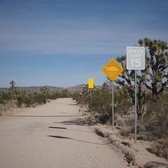
A little further up Wee Thump Road
I arrive at the dirt road leading off Nevada Highway 164 and find trees ahead along the road. The forest was not just any forest, but a Joshua Tree forest, a type of tree I had seen in my previous adventures down in the desert, but only few and far in between. This area was thick with them, at least just thick enough that you couldn’t see the horizon, so I’d call it a very open forest. These trees look alien to me – an episode of “Star Trek” could have been filmed here, pretending this is an alien landscape the crew beamed down to. I was really happy to be in one of these forests without a bunch of other people around. Why go to Joshua Tree National Park when this looks just as nice to me from what I can see.

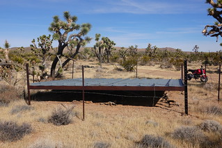
Don’t camp near these watering holes if they are active.
I drive up a good dirt road coming to a corral and watering facility. You are not supposed to camp near these, but I can see this one has been decommissioned for some time. There is a big parking area here you could camp several rigs at. But it is a little closer to Nevada 164 than I’d like. I could see another spot further up. This turns out to be a trailhead for the El Dorado Wagon Trail. They have some informational signs that tell me this was a route coming from California heading to Nelson, Nevada where there was mining way back when. The parking area here is smaller, but I decide to tuck myself into a corner rather than risk going further up the road, which is becoming a bit sandy. The googles showed me another spot further up which turned out to be quite nice as well, just a little more challenging to get to.

Joshua tree view
I was happy with my spot – the trail looked to be little used so I was not expecting much traffic on the weekend for hikers. In fact, one family came up from Vegas to hike the wagon trail on the weekend. They turned out to know something about the current environment of the area.

Grass height exaggerated by camera on the ground to take picture.
The tinder dry grass you see is due to the unusually large monsoon rains in the summer. The grass took in all this water and grew lush and tall this year under the Joshua trees. You certainly don’t want to have any fire here – one spark could set the whole area on fire. A lot of the grasses are not native – so the invasive grasses grow thicker than the native varieties did. The trees can come back, but it takes a long time and they are vulnerable to vermin with new sprouts.
While climate change may be causing more lightening fires, the introduced non-native grasses provide fuel for a fire that can spread much farther.  Humans are changing the world by more than just the weather. Perhaps some day we might manage the understory by having controlled burns, but right now the National Parks Policy is for total suppression of fire on the grounds the ecology is not understood well enough to tinker with controlled burns. For those who scream to keep it natural, that boat has sailed. You are never going to get those introduced grasses out now so we just have to figure out how to manage the forest in this new reality. It is so nice to be able to use some of my BSc. Ecology knowledge though!

What is left of the El Dorado Wagon Trail
I of course had to hike up the El Dorado Wagon trail. The wagon trail is very lightly traveled by foot. In fact, the trail peters out to nothing about a mile out. The forest is open enough that I could just beeline along where the wagon path should be using the googles for navigation. However, the grasses turned out to be of the itchy kind, clinging to my socks. I wished I had a good set of cowboy boots for this stretch. But I made due with trying to keep away from the grass as much as possible, walking along the washes when possible.

Walking Box Ranch building
I put the Grom motorcycle to good use during my visit here. I visited the former Walking Box Ranch, now a BLM local office. You can see a lot of signs of ranching in the area, but it looks like the BLM bought this one out and have let the land return to nature. At least in this area there would be grass for cows. Some areas, I wonder what the cows eat period – the vegetation is so sparse.
The cattle guard ahead is actually part of a turtle fence.
The ranch had turtle fencing, along with a warning sign for turtles crossing. The turtles turned out to be Desert Tortoises, the BLM ranch was probably harboring Desert Tortoises, as they are struggling to survive the environment they find themselves in now. I only wish I had seen a Tortoise while I was out here!
Guzzler with Grom for scale
I saw my first guzzler while I was here too. They collect water on the sheet metal and drain it into tanks underneath. I can’t see on this one, but there should be some sort of container that the animals can drink out of. I would assume this one is for wildlife, as I see no access for cows on this one. I had seen ‘guzzler’ marked on topo maps down here. Now I know what they are, I had thought they were some sort of artesian well.

Corral and water trough
I also took the Grom back a bit further where there is still some active cattle ranching. My target was a well marked on the map, which is setup for cattle to come drink. I was also interested to note that I had climbed high enough to leave the Joshua Trees behind, being replaced by Cedar Trees. It is a nice area, but I was not able to linger long as I had arrived late in the day.
 The views coming back down were great, looking at all the Joshua Trees in the distance. I was getting better riding the Grom too. Not only did I have to deal with rough roads, I also had soft sand to power through, with the wheels slithering along. I spent a fair bit of time putting my feet down to keep the bike upright as it slide sideways trying to get purchase on the sand. I’m trying to be as cautious as I can as I try more difficult roads – don’t want to fall and break anything out here!

Tree, rocks and holes
On one of my last days there I took the Grom up a dirt road to where I could see some lighter colored rocks in the distance. That was the roughest road I had tried to date, probably a little more than I should have attempted, but you get close and the road is only slightly more difficult. Before you know it, you are trying to climb a mountain goat trail. But I made it up the hill to the lighter rocks. As I got close, I could see they were covered with holes, with who knows what inside. I know, there usually is nothing, but if you can’t see to the back of the hole, the unknown leaves you wondering.
 My supplies were running low after my usual week long period I stay at a spot. It was time to head to my initial destination in the desert: Quartzsite, Arizona. I had an appointment to finally get my solar upgraded. I also would be hitting familiar country that I had visited in my previous RV rental adventure. I was wondering how crowded things would be, since COVID had brought so many more people out. See you next time to find out!

Pingback: Joshua Tree not so treed | Ratsofrass