
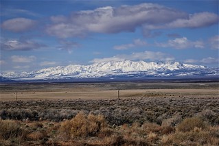
Snow in the mountains as I head north
I only had a week left of my time allowed in the States, so it was time to really put on some miles and get back to Canada. It was going to be two long days of driving, then a short day to get to the border. It sucks that I am not seeing much of the northern half of the continental USA, but that is the way it works out usually – being chased south by winter and chased north by the six month stay deadline in the spring. In my case, it was only a 5 month stay as I had been in the States previously for a month in the spring. This was putting me back in Canada in late March, a bit early for spring in most parts of the country. But I had a plan to mitigate this somewhat.
I know that Kootenay Lake never freezes during the winter in Canada. I’m sure that will come as a surprise to some Canadians, as most everything else freezes, except a few lakes in Southern BC. The open water means that the climate in the valley is a bit milder and spring comes a little earlier too. I was counting on that to be able to camp snow free up there, then start heading towards Alberta as spring caught up with the rest of the country.
 But first I had to get there. I had about a week before I’d exceed my six month stay limit – with only two and a bit days of driving to get to the border I had enough wiggle room to account for any unexpected delays. I’d rather not explain to the IRS that I was delayed getting back to Canada to avoid paying USA taxes. This time, I was driving mostly up Route 93/95, being more direct but perhaps a bit slower. I’ve learned that the speed advantage of the Interstates applies less to me as I’m usually not doing the speed limit. When using the googles maps ETA, I need to add ten percent as I’m going slower than the googles expects. That means that the fastest route might be a more direct but slower route which I manually need to figure out after googles gives me my route options. One good thing is you can tick an ‘avoid highways’ option that will have googles avoid the Interstates, but you should still be careful about it picking some really crappy backroad.
My first travel day had me crossing Nevada south to north. The State is longer than I expected. Looking at a map, you can see I was doing 2/3rds of a length of California. No wonder it took me all day to just barely make it into Idaho. My other unexpected travel note was how empty the countryside was. It is mostly low grade cattle grazing country, with the occasional town interspersed along the way. I would have expected a few more towns along the highway corridor, at least of the gas station and corner store variety. To be fair, the googles took me down Nevada 318 for a good ways – that I was expecting to be pretty empty. But it goes to show, auto travel pre-Interstate didn’t always have a town with a gas station every few kilometers.
As I headed north, the mountain snow started getting lower and lower. I had hoped to avoid the white stuff, but was expecting to drive through some in the higher northern areas at least. Late March is definitely still snow season in those parts. But at least the weather had been good for the last few days so I was not expecting any snow on the roads.
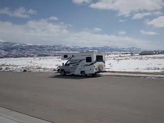
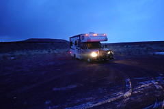
Parked back in snow in Ely
I was not to be spared the snow, in fact I would see plenty of it along the side of the road as I arrived in Ely for my lunch / gas stop. I was beginning to wonder how much snow there might be north of the border with there being so much snow this far south. But I was high up in snowier country here – surely things would be better in the low valley?
I continued north through Wells, continuing the long drive north through Nevada. At least the snow was left behind, hopefully for good! But that was not to be. As I approached the north end of Nevada on Route 93, snow started to appear again as I climbed. I stopped in Jackpot, NV for a quick leg stretch and a scout ahead on the map for potential night stops close by. As expected for a border town on a highway in Nevada, there was the requisite large casino.
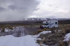
Overnight by the snow. Freezing ground by the time I got there.
Refreshed, I continued northward racing the setting sun. I had decided to try a spot just a few kilometers into Idaho as at least I would have time to check it out in the last light, rather than getting myself north of Twin Falls where the camping apps showed some potential spots. I’d have been there after dark – never a good thing trying to explore an unfamiliar area for a night stop. I turned off the highway on a good road that led to some sort of monument. It is just a loop now, and I can see that people do indeed camp there. It would do for a night, but it is quite close to the highway. There is a road heading up the hill that is mostly dry with melting snow around. I take a little walk up it and find it is indeed drivable to a level spot further away up the hill. There is more snow here, but I will be gone first thing in the morning. Even if the snow starts melting into the road making it muddy, it will happen after I leave.
Pre-dawn start
I’m glad I explored a bit and found a spot further away from the highway. It’s busy enough that there is all night traffic – I only get a dull roar in the distance from my spot above. I awake early as the light is just starting to show me my surroundings. I’m not sleeping until well past sunup like I normally do today – it’s get up and get going. The cold night means the ground is frozen, so not even a chance of getting stuck anywhere as things are all solid ice again.
Today’s mad dash north was going to be a bit longer than I’d like, thus the early start. I drive around Twin Falls and hit the I84 going west. This takes me to Boise, Idaho. I exit the Interstate and end up going through part of the city. It looks cool, but I’m not really able to stop and look around. A few turns later, I am on Idaho 55 northbound, leaving Boise. The local road climbs into the hills forever, taking me up a steep valley eventually into the forest. I stop in Cascade for a quick lunch in the parking lot in town central. Again the town looks cool, but I don’t really have time for a walk to explore things. I need to get going to make my potential stopping area before dark again.
I continue north, with only a gas stop near Lewiston, near a casino. I actually entered the casino and walked around in just to stretch my legs. The casino was not large by Nevada standards – I could not even see card tables, although they could have been hiding somewhere in the sea of slot machines I did see. There was certainly no temptation to play slots – I’d gain almost as much enjoyment out of burning money. Gas is the only thing I’ll be spending money on in this part of the world.
I continue north to Coeur d’Alene, now confident that I’ll make my first potential camping spot before dark . I’m driving up Route 95 at this point. My spot I want to check out is called Granite Lake, from my research it is a little camping spot with a small lake across the road. Certainly good enough for a night’s stay if all is as I expect. I was also looking for stuff not far off the highway – I didn’t want a lot of time wasted traveling to and from the highway. This spot also had the advantage that I was less than two hours from the Canadian border. I’d be early in the day arriving and fresh, which I was going to need for my complications I’d have there. You’ll note, I wasn’t stopping to take pictures anywhere either.
But in the meanwhile, I would enjoy my one night by Granite Lake. I had been fortunate to arrive before sundown, so I had just a little bit of time to wander over to the lake and check it out.
 Granite Lake by my camp |
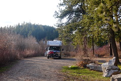 The one small camping area at Granite Lake |
Unfortunately, the lake was still frozen, but getting very close to opening. Good thing I guess, I’d have been tempted to fish otherwise, not that I had the time for that. Granite Lake allows three day camping, so I might hit this again at some point to visit for a little fishing, who knows!
But I was just happy that I had a decent spot, although the road did have some traffic leading to a village just down the way. Even the train noise came up the valley to the lake here, a bit of a surprise to me. But I still slept well, ready for my encounter with customs returning to Canada.
I was a bit concerned about how this return was going to go – I had a considerable amount of duty items, and was going to owe tax at least. To complicate matters further, I had misplaced my receipt for my cell phone, so we’d see how customs was going to deal with that! Now that I was close to the border, I knew I had a shorter day of driving ahead of me to reach Kootenay Lake. I could afford to sleep in a bit after all that driving.
I stopped for one last fill of cheaper American gas and continued north. By the time I got close to the border, I decided I’d rather face it on a full stomach and looked for a spot to pull over for lunch. Of course, now that I needed a spot, I couldn’t find anything to save my life. I finally turned off on a side road not too far on the border, expecting to find some pull off somewhere, but still ended up going way back before finally finding a spot to stop by a cemetery.
I stretched my legs a bit and note the peculiar sign noting that the water tap is on the other side of the border. Sure enough, referring to the googles, I see I’ve come far enough north that the north end of the cemetery is the border between Canada and the US! The map shows me that it would be quicker to continue down the back road, which is narrow but at least paved, coming back out just south of the border entry.
I did this, thinking that if they actually track the vehicles approaching I might look a bit suspicious for having stopped just south of the border before coming over to customs. But my bigger issue is my customs declaration. I have to explain to them that I don’t have the receipt for my phone, which we end up estimating a value for. My motorcycle is of some interest to them, being new enough looking that they want to make sure it wasn’t purchased in the US. I am not surprised when the customs people decide they want to take a look through my rig.
I’m not too worried at this point, there was a moment of tension over the phone value issue, but I can see watching them going over to my rig that they mainly want to verify that my motorcycle really is a Canadian purchased one. There isn’t more than a quick look inside my rig. They return and take take my money, sending me along my way. I’m happy to be gone with just GST owed – not having been sure how the phone thing, not to mention my solar install was going to be assessed. I could relax now, and make my way through familiar territory to Kootenay Lake.
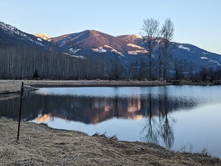
Ponds near Kokanee Campground
Now, I wasn’t completely out of the woods yet. My plan was to stay in an RV park on the lake, scouting out to Garland Bay Recreation site to verify the road was clear of snow. I had not verified that the RV parks were open yet that I was considering. I thought that if one was closed, surely the other two of the three I was considering would be open and I’d be good to go. Getting to the second site and finding it not open had me re-evaluating my plans. But there was a receptionist on duty for the hotel part of the property that made a call to see if Kokanee Chalets / RV Park was open.
Fortunately, it was. I realized on arriving there that I was quite fortunate, as most of the park in the shade was still covered in snow; only a couple of spots that had been plowed in the winter were open. But I was set for a week, with power and sewer, with water if the weather stayed warm enough to keep the tap thawed. (It was unusually cold, freezing taps should not be an issue at this point here) While I wasn’t directly on the lake at this park, at least there were some nice ponds nearby to walk to. With all the snow in the area, I was definitely going to be scouting around to see if the roads were open yet. You’ll have to tune in next time to see how that goes!
