
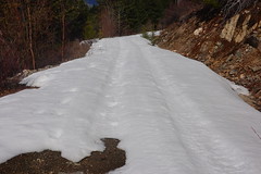
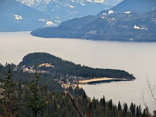
 My early return to Canada meant I was likely to be colder than I’d like. I’d come to Kootenay Lake, which tends to be a bit warmer thanks to the water, but it was still cold. I was paying for camping in Kokanee Chalets and RV park. There was still snow on the ground in the park, that did not bode well for going out on the forestry roads to boondock. I was hoping for proper spring to arrive, with warmer temperatures and melting snow so I could move over to a free and better camping spot.
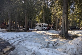
Kokanee Chalets and RV park and snow
In the meanwhile, at least I was hooked up so I could run my electric heater as much as I wanted. My water was not freezing, mostly. The temperatures were dropping below freezing every night, it was always a question of if my water would be working in the morning when I first used it in the coldest part of the day. I certainly was not happy to be crunching through snow in the shady areas of the campground. I had hoped for a normal year where the snow is gone by late March at least in the valley bottoms around the lake.
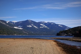
Crawford Bay
While I have spent a fair amount of time at Kootenay Lake over the years, I had not been in Crawford Bay since I was a kid, and never to this campground. There was a nice coffee house on the site, but it was closed for the season. Good thing, as I’d have spent some money there with it being a one minute walk from my RV. The rest of the campground was a mix of Chalets you could rent and RV pads in the trees. There is even a hot tub, closed of course while I was there. There were one or two Chalets occupied while I was there and just me in the campground. With there being no fishing here, there isn’t much reason to be here right now – snow season is done, but hiking season is not quite here yet.
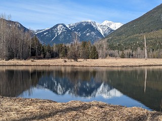
Crawford Pond
But down in the valley there are a few hikes open already. There is the Crawford Bay Wetland trails, going right by the edge of the campground. These provided me with some nice strolls over level ground. The lake was about a kilometer away giving me a nice walk to start or end the day. There is also a nice pond in the wetlands to watch birds on the water.

Church up Crawford Creek Rd.
The settlement of the area goes back to the early 1900s, so there are a few old buildings around. I took a walk up a road that led to Kurt’s house, a friend my Dad used to visit with me when we came here many years ago. Judging by the look of the house, I’d say it has different occupants now, although I am curious if the children kept the property or not. The church was a cool find along the way though – these are often the oldest buildings in the area. They were often one of the the first things put up in a newly settled area, if the original survived it could be one of the oldest buildings still standing in an area. This one’s age is unknown to me, it is just hidden along the side of the road I was walking up, not really central to anything.
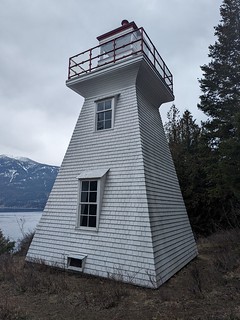
Pilot Bay Lighthouse
I got the motorcycle out on one of the days where the temperature managed to creep a bit more above freezing. My destination was a a little walking trail that would take me to Pilot Bay lighthouse, a small historic lighthouse no longer in use. I was surprised at this, I remember the lighthouses still going when I fished on the lake with my Dad years back now. Early in the morning, we would rely on the lights to get us out in the general direction of our fishing spot before the sun came up. But I guess with most of the commercial navigation gone and everyone on GPS navigation now, these markers of the past are not really needed.
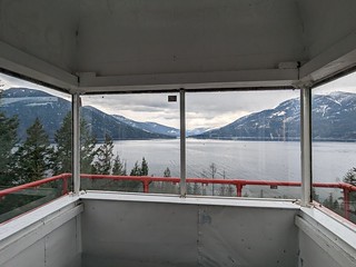
View to the West Arm
The lighthouse is even open, so I could explore inside too. These lighthouses are not very big – no one would have lived in here, although the base is big enough for a bed and over night shelter if need be. You can climb to the top and admire the view, although the stairs are steep enough to be half way to ladder rather than stair up. I could have wished for better weather, but at least I didn’t get rained on while hiking the short distance to and from the lighthouse.
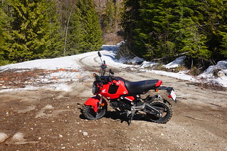
At the road going down to Garland Bay
I took the motorcycle on another day to Garland Bay to check out the condition of the road. It definitely was still too snow covered for the RV. In fact, I parked the motorcycle near the top of the hill down into the campground rather than try to fight my way back up the road.
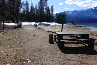
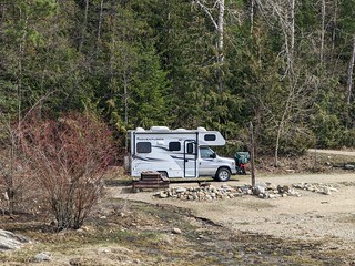
My previous camping spot empty
The campground was empty at this point – only a few 4x4s had been down to visit at this point in the season. My favorite spot was snow free – ready for me as soon as the snow melted enough! But in the meanwhile, I scouted out some potential spots to stay on the way in where the snow would be melted sooner. My frustration was the cool weather. It was cool enough to snow some nights, which was not helping getting the roads open.
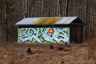
Former washrooms graffitied
I had booked a week at the campground. Worst case, I could stay another week, which would be annoying as there was only so much stuff to see where I was. It is a better place in the summer when more stuff is open, but in the meanwhile I kept myself amused photographing the old airfield and picnic beside my campground. The airfield is gone now, but the old picnic grounds still have the remaining old washroom all graffitied up hidden in the trees. A new picnic area with new washrooms has been built on the end of the old runway. I’m not sure why the old facility was considered no good anymore and left to decay – it was in a better location closer to the water, all that was needed were some road upgrades and a washroom reno. But it left me with a building to photograph that is more interesting than the new washroom at least.
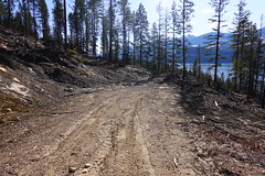
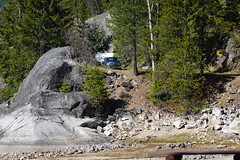
Dead end newly logged
With my week up and things still pretty snowy, I decided on my most conservative boondocking choice up the road to Garland Bay. There was a new boondocking spot created by some fresh logging in the last year, but the road was a bit too muddy and snowy for me to risk going down to it. Not to mention, the site was still pretty muddy from the fresh logging. We’ll save that spot for another year.

Trust me, it didn’t fit.
I had scouted out a spot just north of Riondel , but it had an issue too. There was a rock slide about half way up the side road I’d be taking to it. It looked possible to make the narrow passage with the RV, but I’d have to pretty much try it to see. As a ‘Plan B’ I could at least camp before just up the main road junction where there was a bit of a level spot, just not private from the main road. I get there and maneuver my RV in between the rocks. No matter what I do, I just can’t quite fit, it is a matter of a couple of centimeters more clearance I need. The rocks are too big to move by hand. ‘Plan B’ it is then!
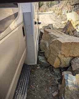
Couple of centimeters to spare, after moving the rocks
I’m not liking this spot, being visible from the main road. The road to Garland Bay has a few cabins on the way and the locals were driving back and forth opening things up for the season. I wasn’t that level either. I walked back up to the partial road blockage the next day, determined to use some physics to move some of the bigger rocks. I only needed about 5 cm added width to make it through with a bit to spare. Finding a small tree as a lever and a rock as a fulcrum, I started the work of slowly prying the bigger rocks over just a little bit. It wasn’t easy – rocks were on top of rocks leaving me little flexibility in what I could move. A half day’s levering later, I was sure I had enough room. I’d measured both RV and gap to be sure. I fit through, driving very carefully and checking every meter moved, sometimes backing up and adjusting my angle to be just right.
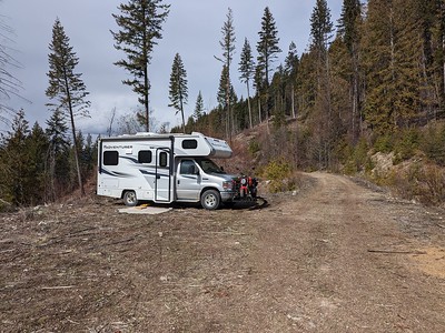
This spot was worth the work
I had been motivated to do all this work because the spot past this gap was much better than being parked at a road junction. This side logging road got almost no traffic, and I was not visible from the main road. Plus, I had a bit of a view of the lake, and full sun for a good part of the day. I was confident I could get back through my narrow spot going back easier. My experience and a slightly less complicated road jog through the rocks going back had me not worried about my exit. While I’d rather be at Garland Bay, this would do for another week until the snow melted enough.
Pebble Beach shore camping spot
From this spot I could hike up the road into the snow, or down to the water at Pebble Beach Rec site. I started with Pebble Beach, which is a site you either hike or boat to – no taking the car in here. The hike isn’t long, but it is a fair ways down – you’d want to ration the number of beers in the summer walking that down. Boat is the easier way to get here, you just have to be willing to beach on the pebble beach if you’re staying with your craft. I had a nice day visiting there and was happy to see the snow gone from down there!
Typical hike end up the roads
Going up the roads was less satisfying. There was too much snow still up high to get anywhere interesting. Pretty much every hike I did ended up in me turning back and heading down rather than get all foot wet trudging through the snow. I didn’t even find much for boondocking up there – you need to get high enough to get out of the main valley, and then even if there were spots, it is hard to tell anything with it under snow still.
Same spot, because it’s in the sun
But at least it was warming up and the roads were getting better. I took the motorcycle down to Garland Bay again and deemed the road to be good enough to get the RV in after a week in my ‘lake view’ spot. A re-supply in Crawford Bay and a drive back down the road and I was finally in Garland Bay, camped in the same spot I had been in previously.
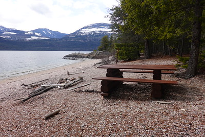
 I started my time in the campground under raining conditions. That had a good side, because the rain is what had finally allowed the roads to open up enough to get in. The rain brought warmer weather too, which stayed around after the rain left. I was happy to finally be outside without freezing my ass off. I could sit at the picnic table for lunch and enjoy the warmth of the mid-day sun.
Campers above and behind my spot
I had the whole campground to myself, but not for long. The spring break had a family with kids come in and camp, plus a couple of one – two night campers over the weekend. At least with my spot, everyone was spaced out. I had campers behind me over the ridge I was under, out of sight, and mostly unheard except for one night when the parents got a little wild with a late night tear through camp with their ATV. The kids were just old enough to be learning how to ride – I’m sure a couple of years from now they’ll be the ones tearing through camp at all hours. But spring break came to an end, and I was left with the campground empty again. It goes to show you, these popular campgrounds get traffic as soon as you can get to them – Canadians like to get out ASAP these days for their first camp of the season.
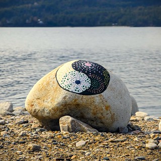 There was a fairly large collection of painted rocks left behind, including one large rock at the shoreline with a very nice Yin-yang painted on it. It sits what I would guess is just above the high water line so hopefully it stays awhile for others to enjoy when visiting the water.
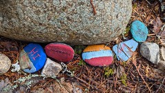
The kids had scattered rocks all about the campsites and in their little play spots hidden in the trees. It turned into a treasure hunt for me on my little walks around camp – I never knew what I was going to find hidden in the trees or at a campsite.

Pre-cell phone calling device
I did some exploration around the area too. Having the motorbike meant I could ride down the boring road part and then hike, or go into Riondel and explore around a bit. I had walked into the village from my previous spot, but Garland bay is a bit too far to walk in. Riondel has a nice campground on a pebble beach – it’s pay and not open as early as I was there. I noted a pay phone still existed at the office, looking like it was not in service anymore but still in good shape. The cell signal here is good, so no old-school tech required here. The rest of the campground does look to be newer than the pay phone – it would be a nice place to pay to stay. Riondel even has a small grocery, so you can walk over and re-stock any basic supplies you might need. I was disappointed the local pub was not open yet for the season – I would have gone in for a beer and a burger.
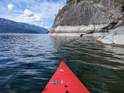 The weather finally warmed up enough towards the end of my stay that I could get out the kayak and get on the lake a bit. I did a little bit of fishing but was not expecting much – the fishing is not what it once was and I was not set up really for catching these. But it was nice to paddle around on a calm day. You don’t wander too far on this lake with a little boat or kayak. Rough weather can come up quick and the waves will take out any small boat. I contented myself with paddles along the shore – not going too far and always trying to start my trips upwind so I knew I could get back. Even with that, I have seen the wind change direction suddenly on Kootenay Lake – you still have to be wary. Any longer trips I’d be setup to at least emergency camp on the shore if rough waves suddenly hit.
 That about covers my month visiting Kootenay Lake. For an early spring destination, it didn’t turn out too bad, but given my choice, I’d show up closer to mid-April to improve my chances of avoiding snow and cold weather. I took a ton of pictures during this time. If you want to see the rest, this album on Flickr will let you explore all of them. Next time, I move on to another much smaller lake!
