

Cemetary in San Bruno
We were headed north, which seemed weird. There had been no obvious destination where we went ‘we have arrived, time to turn around’. We were just heading north because we had not felt like heading further south this time. But isn’t that the point of travel life, to go the direction you feel like going ‘just because’? It was to be my last few days with the group before I had to head north much faster. I had a meeting to make in Texas, so I would have a reason to head north much quicker soon!
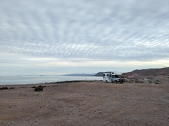
 But in the meanwhile, we passed through Mulege going north this time, onto a new destination of quiet camping in a nondescript bit of desert. We all were craving a few days of just sitting parked with no one coming to pester us for pesos, or partiers showing up unexpectedly. The best chance of that was to find a spot in the middle of nowhere, far from any water. That is not too hard to do in Baja – there are roads going out all over the place. The trick is to find roads good enough for RVs with some spots for a few rigs to park at.
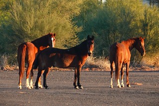
There were several more including one that looked like a mule-horse
We found a nice boring spot that was exciting to us in that we could drive to it easily, we could park easily, and we likely had the place to ourselves for as long as we’d like. Well, it almost was to ourselves other than a couple of people coming through hoping to get to the beach from where we were. Nope, can’t do that here, nothing to see, move on. The area did have some nice desert plants around and there was a mostly abandoned airport nearby to visit.
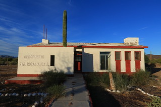
Airport terminal “Rosalia”
The airport that is mostly abandoned turned out to be interesting for what it might have been, but never was. According to the googles, we were at Palo Verde Airport, but not much else to say, other than a couple of peculiar reviews. The Wikipedia entry doesn’t add much more than the obvious to my information.

Note the washed out bit ahead
A visit to the googles aerial gives you the most critical information you need to know about this airport: the runway is inoperable, having been partially washed out and covered in debris from various storms in recent times. You can see faint helicopter pad marks that look like they might still be serviceable. A visit was in order to find out about this strange place.
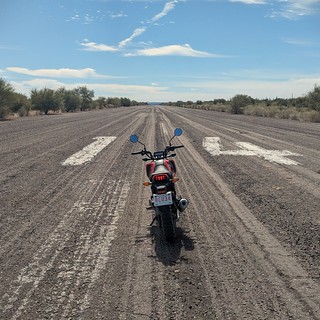 Exploring with my motorcycle was definitely a good call here. This isn’t some little county airstrip – a mile long runway with a long taxiway and parking for at least 737 level of craft was available here, so the place is big. But a run down the main runway confirms that this was once a paved runway that probably could take most any modern jet. Now, it is a sand and wood debris covered mess, with some chunks washed out. Even taking the motorcycle from end to end was a challenge in the sandy bits.

Runway to the left of this picture
Visiting the terminal building, I see the tarmac here is still in decent shape, with what looks like spray painted helicopter landing pads for two near the building. They look totally usable for at least landing. The building looks usable until you go around back and find the missing back door, letting you inside to see the gutted remains of the building. The place clearly looks like it has been salvaged and left to rot, but only recently. There are no smashed windows, no graffitti, no bird poop even. At this point, the bones of the building are good and it could be salvaged for something, even if just for the helicopter landing pads. But I suspect the place has been left to rot after one too many storms damaged the runway.

Shower remains
A bit of digging on the ‘nets tells me that this runway was indeed built in 1988 in the hopes of attracting commercial flights from out of country, but it never was more than a regional destination for the area. One Baja forum from 2009 mentions damage to the runway leaving it inoperable. One archived Baja web page gives me just a very brief history I mentioned. A look through the googles earth historic aerial imagery reveals an airport that existed at least as far back as the 1984, with the runway being marked with closed ‘X’s in 2006, a working runway in 2012, lots of wash materials in 2014 partially cleaned up, but the never fully restored to a functioning runway after that. The major wash that is just south of the airport invades the area each time there is a major rain event in the area – I’m guessing the local authorities just gave up on trying to keep this airport running as too expensive for the little traffic it was getting. It is peculiar that there is so little information on this airport. Half the sites assume it’s still running – there are a bunch of sites just scraping the same out of date information. It did make for some cool exploration – I’d never explored an abandoned airport, small terminal and all.

Walk up beer store at the waterfront
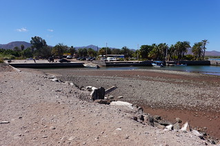
Harbour at low tide, no water
I did an exploratory run into San Bruno, to see about a bit of resupply for our group, explore town a bit, and search for boondocking near town. The resupply was pretty sparse here. The googles makes it look like there are several stores here, but all the “Tecate” places are really walk up liquor stores. You just go to a window and ask for what you want. There actually is one grocery store that I could find, it had pretty limited supplies. But I wasn’t expecting much, San Bruno isn’t very big. The harbour is pretty nice, other than not being deep enough. At low tide, most of the area is a gravel bed rather than water. But it looks like storms have washed gravel in here so perhaps it was deeper at one point. You can just get a small boat in at least, so it probably isn’t high priority to fix.

Grom on a boondocking spot
I did find a nice boondocking spot on the beach just outside of town. There is room for few vehicles, but it’s a little tight. It also is just out of sight of most of the inhabited buildings, so you’re not going to have solitude here. I’m sure people will come park here on the weekends and hang out, as expected for a beach spot you can get to easy. That is, you can get to it easy with a 4×4 the way I came in.

Cemetery just off of the beach
I found out that the road along the water leading out of town had a nice 20 meter stretch of deep sand that was just uneven enough that you couldn’t just speed through it. But there was another road coming to the spot that went right through the middle of the town cemetery. That road turned out to be the way to come in with an RV, it was good and firm all the way to the beach. Plus, I got to see one of the many colorful cemeteries in Baja.
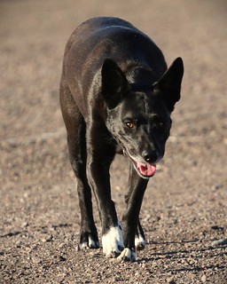 While hanging out in the middle of nowhere was great for recharging the batteries, I was out of time. My friends could stay longer, but I had to head north in a hurry. We had one last fire together and split one of the wonderful porter beers I had gotten in Mulege. In the morning, I packed up and said my goodbyes. I have never traveled this long with a group before, it was certainly going take some getting used to again being on my own. I was going to miss Aaron, Sara and Carolyn, and don’t forget Sadie, my doggie friend!

Already obscured by bushes
Off I went in the morning, not leading, not following, just on my own. It’s never felt strange until now. I’ve lived most of my life on my own, but now it was like an old sweater I had not worn in some time – I needed to get used to wearing the lifestyle again. My plan was to get to Dallas, Texas in a week. I would have to do some longer days driving and I had two off days to rest in there. So we are not talking a cannonball run north and east by any stretch.

Popular stopping spot Santa Rosalia
The run was happening quick enough that I didn’t have much time to contemplate my return to nomad lifestyle. I was hoping to make it to our first beach spot we had camped at just south of Puertecitos. That’s 6.5 hours of driving according to the googles, 8 hours real driving in Baja terms. The googles definitely assumes you are going faster down there. I was doing fine, having climbed out of Santa Rosalia on the windy road leading up to the volcanic plain of central Baja.

Long climb out of Santa Rosalia
Highway 1 was not going to let me get away completely unscathed. I pass a semi at the same time as some tall bushes right up against the road. I’ve hit little bits of vegetation before doing this, only this time I ended up hitting something more substantial that wacked my right mirror into the glass. I pulled over, expecting to see broken glass or such, but fortunately all I have is a loose mirror which I fixed up on the spot. I certainly got off lightly for a misjudgement by a few inches.
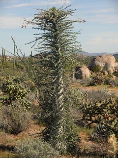
Boojum tree
I stopped for lunch at Guerrero Negro. It’s a good spot to fill up with gas as that gets me back to California on one tank of gas at around 600km of travel. It also gave me a rest before I had to drive the really bad stretch of road between here and the Highway 5 junction. This is the worst bit of highway I encountered the whole time I was down here. I did follow a trick recommended by another traveller online, which is to follow a semi travelling your direction. They know the road well and slow down or move over to the opposite lane as required to get through the rough stretch of road. I did find a semi to follow and can attest this trick allowed me to get through faster with not too many jarring bumps to my RV.
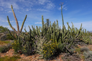
Many cacti at the side of the road
Having passed the worst part of the road, I relaxed a bit driving. Being Baja, I did have backup plans that would not have been as far to drive, but with my only unscheduled stop being for my little mirror fix, I was now fairly certain to make my “stretch goal” destination. I resolved to stop at a particularly interesting cactus forest I had noted on the way south. The area was thick with cacti, including several species I had not seen before. It was good to stretch my legs, knowing that I had good highway ahead of me and enough time to make my destination.
Highway 5 viewpoint
I turned off Highway 1 and onto Highway 5. Highway 5’s southern half is quite a bit newer and built to American standards. While Highway 1 does improve a ways before you hit the junction with Highway 5, it is still narrow. Highway 5 is a relaxing drive in comparison, being wider with a proper shoulder. Only some bits south of San Felipe are old enough to be lower grade and run down. I stopped at a viewpoint on Highway 5. Being built to a higher standard, Highway 5 gets a few viewpoints that can serve as resting spots too if you don’t mind being right by the highway. Highway 1 has gravel pullouts every once in a while. Most of the rest stops coincide with the towns, having roadside food stops set back from the highway, leaving plenty of room for a few trucks or RVs to park.
North of our last spot here
I arrived at my stopping point for the night to find it empty. I’m happy about that because it means I can camp at the other spot that was occupied most of the time we were there coming south. It’s not really that much better, but it provides a different view as I cook my dinner with the setting sun.
A car coming provided some contrasting light
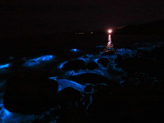
I had taken a quick walk down to the water when I arrived to stretch out a bit. I noticed the water had the same red tinge I had seen at Bahia de los Angeles. I decided to go down after dark, hoping that I might see bioluminescence again. The shore here is quite rocky, so going down in the dark definitely had its treacherous bits. There was no walking in the dark, so when I arrived I turned off my light and waited a moment for my eyes to adjust. Sure enough, there it was! The waves were glowing again in that same blue light I had seen before. This time I came slightly better prepared: I brought my DSLR, but not a tripod. Oh well, wide angle still got me some pretty sharp shots, even my phone managed to capture the effect. The light show was a nice gift from mother nature for my last night in Baja.

Abandoned San Felipe high rise construction
I had an easy run to the US-Mexico border the following day. I did one stop at the south edge of San Felipe. I never really noticed going down, but there is a lot of failed development there. I was parked at the entrance to a large resort, it was quite the elaborate thing at one time with a fancy security booth at the entrance even. In the distance, I could see a high rise building that looks to have been abandoned in mid-construction. It is on a bit of a hill so has a nice view of the ocean. But the construction never made it much past the concrete frame. While I could see business opportunities all over down here, all of these failed ventures gave me pause to wonder what hardships would befall you trying to open a nice full service RV park down here.
But I had a border crossing to think about now, so onward north I drove, onto the nice divided highway approaching Mexicali, and north to the border. I wasn’t doing too bad navigating until I got to my last turn. I didn’t think I had the right entrance, it being so narrow, so passed it by thinking my ‘RV’ entrance would be just beyond. But no, it was not beyond, that area was for truckers coming north. I headed down the road quite a ways before I turned around, coming back and turning into my narrow lane.

Red tide
I come up to a junction where I think I might be able to park just past to go drop off my FMM. You need to return this document leaving the country, at least if you don’t want have problems coming back in a year! I can see there seems to be no parking beyond the junction, everything is coned off into a narrow lane. There is a fellow there who looks to be directing traffic, turns out he speaks great English and directs me to the lane I should have come back on, which was the one I came into Mexico in the first place! But he is very helpful and opens some cones for me so I can turn around onto that road and head back down to the FMM parking area. It’s definitely a bit confusing, but once you know what road to come back on to drop off your FMM, there is plenty of parking, and just a short walk north to the office.
You exit again south, and make a U-turn pretty much back to your ‘exit’ lane leaving Mexico to the north. From here, it’s all just follow the single lane back into America. I had pre-filled out my declaration form to return, but that turned out to be a waste of time. The declaration is done orally coming back in by car according to the customs official. I overhear him talking about an ambulance he was ordering for someone. I query if everything is alright. It turns out another arrival was heading for the hospital in medical distress, it had been decided it would be safer to just have an ambulance come get them at the border.

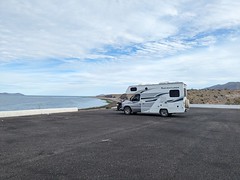
Last camping spot in Baja
With this conversation concluded, I was free to go. No questions! I perhaps got lucky with the distraction and got no questions as a result. Not that I had much for contraband as it turned out. I was a good dooby and made sure I had no fruit. I did have a potato and some sausage I’m pretty sure was no bueno, but no questions, so I enjoyed my Mexican sausage on my return. I was going back to the same spot we had started our adventure at, for one day’s recuperation before I did the long haul to Texas.
Join me next time for my travels east!

Pingback: Heat and power issues traveling south | Ratsofrass