
I had been camped for over a week at Bouse Y. I had hiked as many of the hills as I had wanted to hike. I had been with a great group of people. But, it was time to move on, at least if I wanted to get away from the impending race crowd. I had a general plan: head north.
OK, I wasn’t quite that vague, but my plan was to head north, camp somewhere within a couple of hours drive of the Grand Canyon, perhaps explore a day there, then stay at the Grand Canyon if the weather cooperated.
You see, the rim of the canyon is at 7000 feet, and getting a ways north. Winter proper existed there, with temperatures cold enough to freeze my RV water lines if I was up there during a colder period. The trick was to pick a couple of warmer days so I would have at least a little bit of a chance to see this wonder of the world.
But first, head north. I packed up in the morning, now a familiar routine. I know where to put stuff, and what to stuff together to keep things from moving. It’s not that hard once you get used to it. Moving day is also a good day to empty one’s tanks, which also means it is a good day to have a shower. Use up the remaining water, then dump and refill. Works out well that you come back to “civilization” smelling clean and daisy fresh as well. I had just finished said shower when there is a knock on my door. I’m beginning to think that showering just invites people to knock on my door, I’ve been out of the shower for like 5 minutes and just got dried and dressed. It is David and Melissa, who where concerned that I was just going to leave without saying goodbye. I assured them that I was still packing, and would come by for a visit before I drove off. I was touched, but also wondering why they thought I would just drive off. Had I come off as that aloof?
I get things all set and head over to say goodbye. We chatted for a bit. I’d waited for Ajay to show before leaving. She had finally arrived days late due to her own adventures. I wasn’t going to miss saying goodbye to anyone! They are all good people – but being part of Carolyn’s Patreon group, we’ve kinda self selected for each other, so you’d expect us to have a better chance of getting along. There were hugs all around, then I was off, to my next discovery!

My travels took my back onto highway 95, through Parker and north through Lake Havasu City. I was trying to remember to stop for some interesting scenery, so I stopped at a bridge crossing the Bill Williams river.
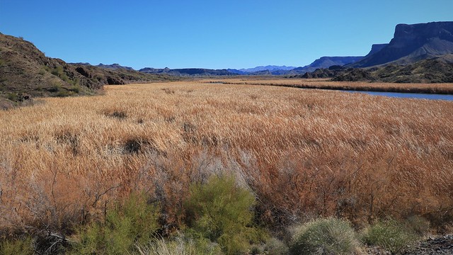
What caught my attention was this delta emptying the Bill Williams River into Lake Havasu, you can see the cattail marsh goes on forever in the flowing yellow of the winter dormant grass.
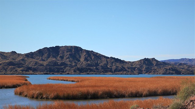
On the other side of the bridge, you see the cattails yield to Lake Havasu, a popular recreation area formed by one of the many dams on the Colorado River. Highway 95 skirts around the south east end of the lake here, then parallels the lake at a distance, coming to Lake Havasu City, a resort town if I have ever seen one. No, I did not stop to see the transplanted London Bridge in the city, even though it was dismantled and removed brick by brick, transported across the Atlantic, and the continent, to be reassembled here, of all places. I had been sitting in “tourist town traffic” for far too long by the time I came to the bridge; I just wanted to get the hell out of town and back on the emptier highway.
North I continued, past some interesting hills and rock formations, but I had forgotten my intent to try and stop to photograph the scenery – the tourist town traffic had gotten my stress levels to the point I just wanted to drive to my destination and park.
Oh, I did have a destination in mind. In fact, I had a “Plan A” destination, and a “Plan B” destination, thanks to a website called freecampsites.net. I had researched a site near Kingman, and another a ways south down highway 93 near a place called Wikieup. I was hoping my “Plan A” site would work out, as it was closest site that still was not too high up on the plateau that is the spine of the North American continent rising to its highest level. Higher up meant greater chance of getting RV freezing weather, which I was trying to avoid.
I had learned from my studies that the area along the Colorado River is the lowest, but as you go east, the land rises quickly. I was going from 500 feet, to 4500 feet – higher than I wanted to be, but I liked the campsite based on the reviews. A look at the weather forecast showed warmer nights for the next few, plus the spot had cell service, so I was willing to take a chance on the cold weather due to elevation. Going further east and closer to the Grand Canyon meant climbing to 6000 feet and beyond. My “Plan B” site was a lot lower, but that meant going south off the Interstate 40 for a good hour to drop back down to 2000 feet.
So, off I went to my “Plan A” site, which I am going to call “Old Highway 93 Camp” for reasons that will become obvious later. Using the googles dropped pin to get me close, I could see after the last turn onto an fairly disused road that there was an exit into the trees. Trees! I see a forest of trees, something I have not seen since California! I drive in and find one other van parked among the trees. My goal immediately becomes to park as far away as possible from the van, preferably out of site. You can see there are a lot of tracks in here, and spots to park. I stop at a little gully and decide to investigate on foot. I’ve become more cautious since my adventure in the sand with Larry!
I walk around the whole area – turns out to not be that big, and there are a few sites that look OK for my rig. A big Class A up here would be tricky up here. The only big spots for one of those would be right off the road rather than in the nice trees. Having walked around everywhere twice, I pick out a spot and carefully cross the gully, head over and park it.

What a nice spot in the trees! Immediately, I am faced with a decision. Do I stay more than one night so I can explore the area, or do I hightail it out of there in the morning for the Grand Canyon? The weather forecast looks good, what to do? I decide the Grand Canyon is priority, we can always come back here on the way back I figure. But I have a good hour before sunset, and I see a mine nearby – it looks too far away to hike to in an hour, but we can head that way and see what is what.

I say that I am camped in the trees, but these really just barely qualify as trees, the evergreens really look more like large bushes. To be fair, I am just in the tree zone – the ridge across the valley from me is devoid of trees, so I’m happy with what I have! The vegetation confuses this Canadian. If I thought this was near home, I’d assume this was early fall, with the mix of deciduous yellow leaves still hanging onto the trees, and some greenery in the hardier plants. But it’s late January! This is what dead of winter looks like here, with only the possibility that snow might be on the ground, not the virtual guarantee I would have back home.
But I don’t have time to be confused. I know I have around an hour before it starts getting dark, time to power hike up the road and see if we can make it to this mine or not!

I hike up the main road that heads into a ranch, and turn off up a steeper minor road that heads to the mine. I’d still call it a road rather than a cart path, but it’s pretty gnarly in places.

The road becomes steeper, I turn off on a very disused cart path, thinking based on my topo map app that this is the way to go. But I see it veers off, fortunately getting my back to the main road in short order. But I have wasted precious minutes getting to the mine. I can see it’s close by – I should be able to make it up and have a few minutes to look around before I have to head back down. Now, I wouldn’t take such a chance if I was hiking through the bush. But here, I have a road to follow – worst case I turn on the flashlight and follow the road with map in hand back down in the dark. It should never come to that, even a good while past sunset there is enough light to see a road you are following back to camp. You need to think of these things when you are pushing time. If I was off trail, and not sure of the way back, I’d be allowing lots of extra time before sunset to make it back.

I see the first sign I’m getting close – I stumble upon a garbage area. While I hate garbage, in this case I’m happy to see it because I know I’m close to the mine.

Nearby, I find an old concrete tank. Past that, this one of the same size as the tank mystified me a bit. It’s not big enough for a shelter, perhaps a couple of meters across, but what is it then? It could have been a pit toilet of some sort, now mostly filled in? I wasn’t going to investigate further. Onward – the mine must be just ahead!

Then I see it – a large tailings pile that is a sure sign we have arrived at a mine of some sort – the Enterprise Mine. Any dilithium crystals to be found? We will see! I check my time – I have a whole ten minutes to explore before I need to get hiking back down to the RV, let’s make the most of it!

The tailings are just piled up against the the gully – whenever there is rain, bits of this are going to be washed down the slope. This would be a minor issue compared to some of the mines that have been abandoned.

I only see a pit, but it is looking like it has filled in part way, there could have been a mine shaft down there that is now buried. I scrabble about, looking at the different rocks. There is definitely iron here judging by all the rust color, but what else I cannot tell you.

But my time is up – time to hike back down while I still have good light. The setting sun does allow for some nice pictures of the hills – light is everything in photography.

While walking down, I follow the road proper this time, and encounter several pits of very white rock with rust color intermingled. It is not as big a works as the enterprise mine, but there is lots of white rock. I poke around a bit, but leave quickly as I’m still a ways away from my RV.


I do get some good pictures in the light of the setting sun. Back on the main road, I walk back to access to the camping area and find that it has a bunch of very old pavement poking out, some washed away, some covered with gravel, some just hanging on. Looking at the map, it dawns on me that the name on the freecampgrounds.net map really is true – this is the old Highway 93, from back before Interstate was built. This road would have connected back with Route 66, which cut to the northeast at Kingman. Once Interstate 40 came through here, this east-west stretch of highway 93 became redundant. Who knows, this might be an even older alignment, with a previous highway 93 following along where Interstate 40 is now. It would make a good set for a post apocalyptic movie set years after the fall of society, where all remaining roads would look like this. This road has not seen maintenance in over 50 years at least! But enough about highway history. I decided, despite other interesting things in the area that tomorrow was going to be the day to drive to the Grand Canyon, this warmer weather is not going to hold forever!
