

An RV could fit down this hole.
My holiday season camping spot near Bouse turned out to have lots of backroads leading lots of mines and other surprises. There is a long mining history here. You just have to look at a topo map to see how much mining activity has occurred in the area. While I wished I could have been a little closer to the hills, there still were some things within walking distance. I had plenty of destinations to pick from with the motorcycle. Read on to see what I saw!
View looking west from the top of the little hill
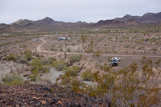
One of my first hikes was to the nearest hill, more to stretch my legs than anything. I walked over and climbed the little hill, hoping to see my rig from the top. While I didn’t see my rig, I did get a good lay of the land, seeing the boondockers nearby had found some good spots. I would have liked to have camped in this area, but after a lot of exploring I determined there is only one good way into the whole area that relies on crossing a soft wash. People have built up a little berm to reduce the slope and firm things up a bit, but I would not rely upon this being here after the next rain event. I was not going to go here anyways as there were quite a few people camped in the general area, so risking the softer ground certainly wasn’t worth it for me. Too bad the access is iffy as once past that wash the road opens up into a lot of areas you can camp away from people. Part of the fun boondocking is finding cool spots to camp. This time, I’ll pass on the cool spots past the soft wash.

A road up the hill went right to the first mine shaft I found
The Grom however had no problems negotiating the soft wash, as well as any roads in the hills leading to the many mines in the area. I used a topo map of the area to see what mines were around. Sometimes you can see evidence of mining on the googles aerials. At least you can see what road goes to the area. My first shaft discovery was on top of a little hill. Like many shafts around here, there is little to no protective fencing, or signs warning you to stay away. You’re expected to be an adult and know the danger.

Muderbach mine shaft
One of the better mines I went to was the Muderbach mine. According to minedat.org, the mine was a copper/silver mine, with a little bit of gold. It was not a really high value property, but some extraction occurred up until 1930. The vertical shaft was interesting, but pretty aquamarine blue rocks were in the tailings here. Across the gorge, some horizontal shafts had even better samples. This mine had the prettiest rocks I found in the area, every mine I found after this one was a let down in the rock front.
Mudersbach or Muderbach, it all had a great view this day
My ride to Muderbach also ended up being one of my best weather days too, with a nice view looking back to the camping along Plomosa Road. The road up to the mine had a variety of terrain to cover, from pretty steep rocky bits to soft washy bits. That pretty much summed up the roads in the area. I got lots of practice with the Grom riding more challenging roads. I still find the soft wash material difficult – you slide out the rear or stall out easily trying to get through. The practice was great for learning to throw the bike around, and good exercise to to boot!

Wash on left drains into shaft on right. The light on the right made for a crappy picture.
One vertical shaft I visited had an unfortunate drainage problem. This was the Toughnut mine. The shaft had been excavated straight down beside a wash gully. Unfortunately, in time the gully has eroded towards the mine, leading to it undercutting the re-enforcement at the top of the shaft and now draining straight into the hole. I don’t know if this fills up every time there is a decent rain, but being the desert, it has not filled up enough to fill the mine with sediment at this point. Certainly this would be a tough nut to mine again if you were to re-open this hole for some reason.

Southern Cross mine viewed from below the shaft
The Southern Cross Mine has some more extensive remaining infrastructure, including many concrete foundations. Perhaps having been worked post WWII until 1958 had something to do with that. The area was worked going back to the 1900’s, which is reflected by the remaining building foundations.

Old stone building overlooking Southern Cross mine

Newer building with cistern in back
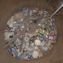
Cistern only has garbage in it now
There are remains of an old stone building nearby. but closer to the mine you find this old concrete foundation of a larger building, including a cistern for water. By the 1950s I expect that miners perhaps had slightly better accommodations than tents, or at least there were more substantial buildings for the heavier equipment and tools being employed. At any rate, the Southern Cross mine was the most extensive works I saw in the area.

Four peaks mine view
These mines were all off in the hills to the west of my camp. But there are mines in every direction there are hills around here. I checked out the spot marked on the googles as the Four Peaks Mine, off to the northwest about a half hours ride by motorcycle. This is a former copper – gold mine operated in the 1940s according to mindat.org. The shaft is on top of a hill, a little too steep to climb with the Grom. I needed to stretch my legs anyways.
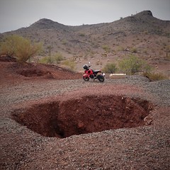
Copper Queen pit – can drive right into it
After this, I checked out the other googles mine noted, the Copper Queen. Even mindat.org doesn’t have much information on it beyond it being the obvious copper mine. As you can see by the Grom, I drove right up to the pit. The road goes down to it. You would not want to be riding around here at night without really good lights and a lot of caution, it is literally possible to drive into a pit out here. I found another pit of unknown name that was right beside the road, on a spot that looked level for boondocking. Backup at night not paying attention and you’d be very unlevel in the pit. At least that spot was far enough off the main road with several tricky bits of road that would keep the bigger rigs out of the area, and scare off most of the rest of them. If you have a dog that has a propensity to check out every hole and try to go in it, you probably want to keep them on a leash out here. If Timmy can fall down the well, Rover can fall down the mine pit.

Guzzler near Copper Queen mine
There were a few other surprises in the desert too. If you look carefully, you will occasionally spot the outline of a former building, most likely a tent that was lined with a rock foundation. A more modern find was the guzzler I found near Copper Queen mine. This was the largest guzzler I had found to date – the metal works collecting rain water extended over two sections, draining into a little trough that is fenced off to keep the humans out.

 The signage informed me that this guzzler was to enhance game hunting opportunities in the area for sportsmen. Sportswomen evidently didn’t pay into this scheme.

Pitch torch in a discard pile
One of my best finds was of an archeological nature. I explore most garbage piles hoping to find something more interesting than a rusty can. This time I immediately recognized the pitch torch discarded on this hillside refuse pile. Imagine mining these shafts back in the day with only a flaming torch to light the way. I’m sure the miners had some better gas lamps at least, but the pitch torch would have been a cheap light, the equivalent of your free cell phone light you have nowadays. I left this bit of archeology undisturbed on it’s slope – a bit of lighting history in the desert.

Malachite I think are blue ones. The sparkly Quartz at 8 o’clock wasn’t evident in the dull light of this photo.
My time here was coming to an end. I had my little collection of rocks near my rig. I took one of the blue rocks and the sparkly quartz with me, the rest will remain along with the other discards we found in our camp. The year 2023 had arrived and it was time to head south to visit Larry, who I had met during my last adventures down here. But first, I was going to try and find a bit of water in the desert. See if I managed to find something to paddle around on with the folding kayak next time!
