

Palm jetty on Mittry Lake, at the main boat launch
I had done some initial research on free camping in the Yuma area. While there is desert camping around, and some cheap long term camping that includes use of water and a dump station, I was after some free water spots. I had previously visited Fortuna Lake. This time, I was headed for Mittry Lake, to see if I could find a camping spot near enough to the water to dip the folding kayak in. I was willing to crowd in with other people to get my time on the water – but would there be a spot available at this popular lake?

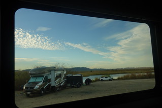
Informal boat launch and camping area
I drove in from Yuma, having done my weekly supply run there. It was nice shopping at a proper Walmart that actually has the selection of a super center, unlike the “super center” that Parker’s Walmart claims to be. I set the googles to take me to the free camping area of Mittry Lake. I’m a bit suspicious that the googles is taking me the long way, but the route doesn’t look too unreasonable: a loop north through the the Yuma Proving Ground, then west, and back south just a bit to the lake. It turned out the googles did take me the long way, if on slightly less gravel road compared to coming in pretty much straight north then a little northwest along the lake. The googles turned out to be less than reliable exploring in the area , but more on that later.

Some ‘art’ around the backside loop
The road in was paved except for the last kilometer along the canal levee. Even that road was a good gravel road right up to the lake. I could see the lake coming up as I drove down the road. There were people camped along the side of the road in little pullouts. While some had a nice view of the lake, I would not like those spots for the dust and close passage of vehicles. I arrived at the informal boat launch/camping area. The area is essentially a gravel parking lot with a cleared access to the lake. A loop provides a few more secluded camping spots, but most of the camping on terra-firma is on the gravel lot. Some people braved the sandy area to the south, but I deemed most of it too soft to go in with a large rig. There was one reasonable spot available that actually had one shrub screening you from the gravel lot – I decided to take that and check out the rest of the area. There was not anything better available, at least not with neighbors within a hundred feet of me.
 I unloaded the motorcycle and took a ride further down the road, to see if any spots were available. It turns out all the good spots were taken. There are a few areas where you have lake access and can be a little further away from the road, but good luck snagging one of those spots. I made it all the way down to the formal boat launch, which is actually a pair of concrete ramps and pavement around them. There is formal camping there too – just boulder denoted spots in a gravel lot. But the area has a pit toilet! This area was quite popular – every formal spot was taken. Had I wanted to camp here, I would have had to drive a little ways away to more informal camping on the hill overlooking the launch.
 Returning to camp, I decided my spot was about the best I was going to find. I was close enough to the water to carry the kayak over there, and I was not right in the gravel parking lot. I would just have to get used to having neighbors close by for my stay here. That was the price of being near water. Speaking of neighbors, my closest ones by the lake turned out to be English Canadians from Quebec. Joe and Linda were kind enough to move their cargo trailer so I had a nice view of the lake from my back window. We also sat around the fire one night with another Canadian – we seemed to find each other in the campground.
 While meeting fellow Canadian snowbirds was nice, I was there for the water. Next day, I unfolded the kayak, looking forward to get on the water during a sunny calm day. I was not disappointed upon getting on the water. Getting out in January for some kayaking is a wonderful thing as a snowbird.
  The water also has the benefit of being away from the people. Once I had paddled away from the boat launch, it was just me and the birds in solitude. The birds however were a bit too solitary for my liking, staying far away from my camera. I wasn’t going in and disturbing them, but they took it upon themselves to add distance to me as soon as they saw me coming with my kayak. Oh well, you can’t have everything! I did manage to get a few bird pictures at the end, but very few compared to the actual number of birds in the area.
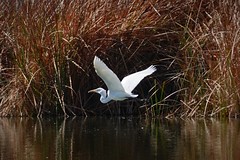
One good bird picture
I was also appreciative of the warmer weather down here in the Yuma area. It was t-shirt weather in the afternoon, and even the nights were only chilly. Getting a little further south, lower, and closer to the ocean makes a difference. The wind managed to stay down enough that I could get out most days with the kayak, the main reason I was here!

No trespassing on most of the roads approaching the dam
There were some explorations around the area with the Grom motorcycle. It was a good thing I was exploring with the Grom rather than the RV, as the googles did not have accurate road mapping in the area at all. The biggest problem was being sent down a road that was either closed or blocked off. Re-routing didn’t even get you on the right road at times. My first foray out to a park by Imperial Dam had the googles trespassing me all over closed roads near the dam. Even my second approach had the googles trying to take me down a levee road that was only open to foot and cyclist traffic. I finally found the way in using old school driving instinct, going “this looks like a main road going the way I want, let’s try that”.

Parking lot camping with park to the left
McKinney Family Park
Once I did find my way, the Imperial Dam isn’t much to see, but the little park has 3 day camping allowed according to the sign on the bathrooms. It’s just a parking lot overlooking a little park – but the park has nice trees, grass, BBQ grills, and picnic tables. It’s really a bit of a stealth camping spot – there are no signs pointing the way to this park, and the only clue people are staying here is a couple of vans you can see are being lived in by the open side door. The park’s grass is a nice change from the rocky desert – but I would still treat this as a one to two night stay area while in the Yuma area.

Sludge dredger
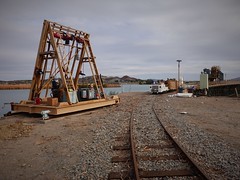 While Imperial Dam does not look like much owing to it being a low concrete slab structure, the infrastructure around it to support the water cleaning is interesting. The first thing I saw at the end of the park was a little narrow gauge railway, used to haul away the garbage and silt dredging from behind the dam.

Channels lead to the de-silting ponds
Then you have the de-silting works below the dam. I did not walk down to the ponds, but could see the channels leading to them. The ponds allow the silt to settle out, which is then flushed out with a bit of water into what remains of the Colorado River below the dam. It is not much, about 90% of the river’s water is diverted at this point.
For you Canadians and Americans, you can consider your winter vegetables to be the fruit of this water diversion.

All American Canal monument
The scale of the infrastructure is impressive. The All American Canal is supposed to be the largest irrigation canal in the world. It looks more like a river going by, other than its consistent straight banks clueing you in that this is man made.

All American Canal a few miles downstream of the dam. It’s big.
Passing the canal, I decided to take a quick visit to what is the cheap camping around here: the Imperial LTVA. That would be “Long Term Visitor Area” for the those that don’t know their boondocking acronyms. For a mere $180 you can camp for the winter, with use of their trash disposal, dump stations, water and toilets. It is a really good deal if you don’t want to explore a lot of other areas and would rather stay put for the winter. While it is a large area, there are a large number of people around. Don’t expect desert solitude here. That being said, my little drive through there gave me the sense that you can get some more out of the way spots further in that would at least provide you with only a few neighbors to look at from a distance.

Some of the Imperial LTVA, near the front more crowded area
 But I was looking for free camping. I was not intending to stay in LTVAs (there is more than one) over the winter down here. I passed out of the Imperial LTVA to the south, having to use the googles aerial to even find a route out – the roads in here are a bit of a maze. Forget using googles maps – that had me going up against another dead end blocked road. I left the sign behind informing me I was leaving the LTVA. There was no sign saying I couldn’t camp beyond here, and the land is marked as BLM, so I should in theory be able to camp around here. But I’m not seeing a lot of signs of people camping long term just outside the LTVA. I did see a few signs further out, mostly where you are a bit more hidden. That has me suspicious that you will get shooed out of your spot when the rangers spot you outside of the LTVA. Considering I did see a ‘no camping beyond here’ sign at another road that lead out of the LTVA, I’m wondering if we are talking missing sign. I’ll find out someday. I did mark a good spot not too far from the All American canal that might be good.
 In the process of finding that, I had gone further out to investigate an area that looked promising on the googles aerials. But it had a wonderful view to the LTVA, with no one camped right in the view – everyone was out of sight behind a little hill or some in some gully. But I quickly forgot about my camping search when I saw the “rock garden” I had stumbled upon in the area. It really was all rocks, not much beyond a creosote bush growing around here.

Looks like it was a pool once
On the googles aerial, I could see a building had been here until a few years ago. I suspect this was the garden for that building. There was a pool sitting on top of a hill here too, at least I think it was a primitive pool judging by the rock work. Looking down at the rock garden, I spot what looks like letters spelled out with rocks.

LA QUINTA
I head over to the letter rocks and see “LA QUINTA” spelled out. It is actually easier to read in Google Earth, if you look back at the right historic imagery. I’ll just assume the Spanish slang for ‘country villa’ applies and the rock garden owner fancied their former house/pool/garden as a villa of sorts. But it certainly looks more like a ‘WTF?’ moment these days.
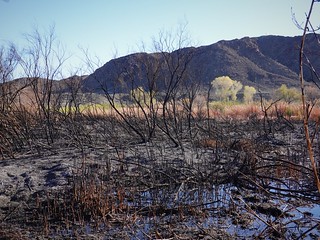
Fire charred former reeds and bushes on the west side of Mittry
I had one more exploratory trip out with the motorcycle, this time to the other end of Mittry Lake to see if the road coming in from that direction would take me back to Yuma quicker. It did. But in the process of discovering that, I found a few other unexpected interesting bits. That is what makes riding around fun – finding the little surprises rather than touring around on an itinerary to all the tourist spots. My first surprise was the remains of fire on the west side of the lake. Evidently, the reeds and brush do dry out enough to burn at times. They certainly are thick enough for a fire to spread once they dry out. But since there is desert as soon as you get away from the water, the fire can go no further too as there is not enough fuel to continue into the desert, most of the time. It is ironic that the fire ends where the water ends in this case.

Laguna Sluceway Gate
In other water infrastructure, I drove by Laguna Dam on my way to check the road out. The dam was historically the original diversion dam for taking water from the Colorado river. The Imperial Dam replaced the Laguna Dam in this function, leaving it to mostly regulate the Imperial Dam release, and impound Mittry Lake. Having been finished in 1905, you will see some unexpected decorations in the area, like swastikas on the sides of the bridge crossing the disused canal works.

Bridge decoration you’d not do today
The Bureau of Reclamation’s unofficial flag of the time incorporated swastikas, a symbol that didn’t have the Nazi added meanings at the time. As these exist on an out of the way bridge, they never got ‘canceled’ out of existence during the war and now point to the fact that the swastika symbol existed with different meanings for a long time before the Nazis. Seeing these reminded me that Alberta prior to WWII had a village called Swastika, that got renamed to Gayford. Truth is stranger than fiction sometimes.

Great sunset dock on Mittry
I reluctantly said goodbye to my spot on Mittry Lake. I had gotten out on the kayak several times enjoying the solitude. That certainly made up for being surrounded by yammering people and their droning generators. It was time to head into Yuma, the quick way this time! I’d be catching up with Larry and seeing some of the sites around town. You’ll have to click the next link once it is up to see Yuma for yourself!
