
 The day dawned with barely a cloud in the sky, unusual weather on Vancouver Island this time of year. I intended to take advantage of the blue sky day and get some fishing in. The forecast was for more good weather following today. My plan was to walk into Coal Harbour and play tourist, snapping pictures with my tourist camera and gawking at the sites. I also wanted to scout a potential boondocking spot near town – for future potential visits. That ended up with some disappointment, but an unexpected surprise as well.
Revisit to Stephens Lake
I was eager to get some fishing in with the nice weather. I decided that Stephens lake (as I call it from the creek it empties into) needed a proper try to catch some fish. My previous visit had been while the lake was frozen with a very thin coat of ice, not exactly good fishing conditions.

The main roads have a coat of mud after the rain, not enough to really be slippery, just messy for walking.

Logging trucks take up most of the road, even on the mains
But first I needed to hike down the Coal Harbour main logging road to get to the lake. As you can see from the picture, the road is a bit of a muddy mess. It’s not deep – your tires will be down on the gravel if you stick to the middle of the road. But be very careful moving over to the side for a passing car – the sides can be muddy enough to slide on, and can be soft enough to sink into in places. Remember, you’re going to be backing up for a logging truck to the nearest pullout. They don’t move to the side of the road even if there might be enough room to squeeze by – a loaded truck is much more likely to sink into the side of the road.
As far as walking goes, you’re going to get muddy – not much you can do about that. But it beats hacking through the bush any day! Walking the main roads is not my choice for a nice walk – besides the mud there is the occasional traffic, so you need to be paying attention. I walk the mains to get somewhere, not to be strolling on for recreation. Now, if I had a small motorcycle, I could skip this main walking and enjoy spots more distant for walks and fishing…

In the meanwhile, I put up with walking the main road to get to the lake. The little dock is a bit more underwater, but that’s OK – the lake is open now, and mirror calm! I give my best effort casting lures, but no luck. This time, I see fish rising, so I am sure there are some fish here to be caught. I try switching to float and fly casting. The fish of course stop jumping and ignore my fly on the surface. I do another round of lure casting, going through most of my small lure box selection, but no bites, no fish for dinner. I’m not too disappointed – the weather is awesome with only a few clouds now and the slightest of breeze. Things are starting to dry out a bit even, but it’s going to take a bit to get these muddy main roads dry. I’ll be walking in mud for my visit to Coal Harbour for sure tomorrow.
Feb 11 Coal Harbour visit
 My visit to Coal Harbour started with a bit of revelation. I’d been breaking the rules driving on this road during a weekday. But while I’ve seen these signs around before, most of them are even dirtier than this one – good luck reading this while driving by! I’d known some roads were restricted during the week, but not like the locals warned me. Things are a bit more casual up here about rules. I’ve been advised several times on different subjects that the rules are more suggested rather than enforced up here. It might be a different matter here in the summer when the tourists are all here. In the meanwhile, I’d try to at least avoid driving these roads during the week. Fortunately, my boondocking spot was only just down this main – if I listened carefully at the junction to the main, I’d be able to hear if there were any logging trucks nearby, and quickly scoot over to the copper mine access road in about two minutes of ‘sneaking’ down the main!

Coal Harbour bus stop on the way out of town
The first thing I see walking into town beyond a few residences is a bus stop by BC Transit. Looking at the schedule, they offer three runs a day into Port Hardy during the week, and two on Saturdays. Not bad for a village of a little more than two hundred people.

Former location of “Lucky Louie’s” and pretty much village central.
Good thing that there is bus service. I find out quickly that the one store I saw in the googles streetview, “Lucky Louie’s” was no longer in business, perhaps a victim of the COVID challenges businesses have been facing. It’s too bad. In a strange coincidence, my Dad’s first boat happened to be named the “Lucky Louie”, named after the lure he caught his 25lb Dolly Varden in Adams Lake. I had hoped to find out if the store was named after the same lure, and what its story might be. Instead I just got to peer in the windows, seeing the remains of a store and restaurant of some sort.


Heading down to the harbour, I come across a couple of small totem poles, facing the harbour. That would tell me they are there to greet the dock traffic coming into the village. I’m not sure you want to concentrate on that direction unless there is float plane traffic ($$$$)? The tourists in the summer will mostly be coming down the road, you’d want to face the totems the other way to greet them ($$). There are a fair number of planes coming in, even in the winter though – I could hear them from my boondocking spot out of town. Perhaps the $$$$ beats the more numerous summer $$ still here. But at any rate, the direction facing is good for photography, as the totems are facing the sun at this time of day at least.

Coal Harbour as seen from the dock
 Walking out onto the dock, there is a bit of evidence of fishing. Most of it is tourist fishing these days. These old boats are the remains of commercial fishing, but to be fair, there was one newer small fishing boat that was prepping to go out. At any rate, the original fishing for whales is long done here. One of Coal Harbour’s claims to fame is that it was the last Whaling Station on the North American coast to close by the time it shut down in 1967.
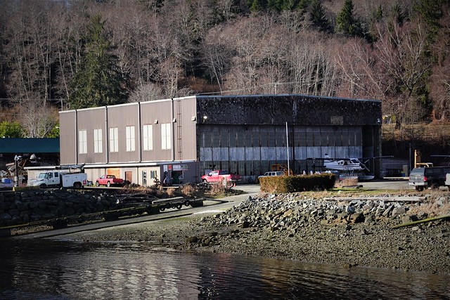
Former RCAF hanger, now float plane base
I come off the dock and take a look at the tourist displays and plaques in front of the harbour. I’m actually referencing some of the information in this post from them. The village has a pretty eventful history for such a small place. To summarize, the village started as a coal mining town, mining closed after only a couple of years. The town then served as a general distribution centre for the area after. During WWII, Coal Harbour’s strategic location in relation to the Japanese led to a RCAF station being setup. The picture above is the hanger, still in use today for float planes that base out of the village. Post WWII the military presence quickly faded, but was replaced shortly by whaling, closing in 1967 as I discussed already. From 1970 to 1995, the Island Copper Mine nearby dug a pit that holds the record as the deepest extracted depression below sea level. All of that, in addition to the standard fishing and logging activity you had over most of Vancouver Island.
The boom and bust activity here helps explain why this village punches above its weight in old buildings. The booms here were never were that big. Port Hardy nearby sucked a lot of the wealth away from Coal Harbour which was just a little too disconnected from the rest of the civilized world to really take advantage of the latter mining boom. So rather than tearing down old buildings and putting up bigger and better, the old buildings were re-used and re-clad. If you were pull up the 2009 streetview image of the “Lucky Louie’s” you will see the original façade, a much more interesting photographic subject than the neat but boring siding you see today.

But there are still interesting bits of old character building to be found – you just have to explore a bit to find the original bits mixed in with the refreshed stuff. The old RACF hanger is a good example – it’s been re-clad differently on all sides – patch work to keep this larger building intact, but not neat. The partial renos add their own character to the building.

North Island Distributors

Nod to the whaling past


I might have scouted around a bit more, but the clouds were moving in and I had a bit of a walk back to my RV. Even though nothing was open to spend tourist money on, I’d had an interesting afternoon in Coal Harbour.
Little scouting adventure
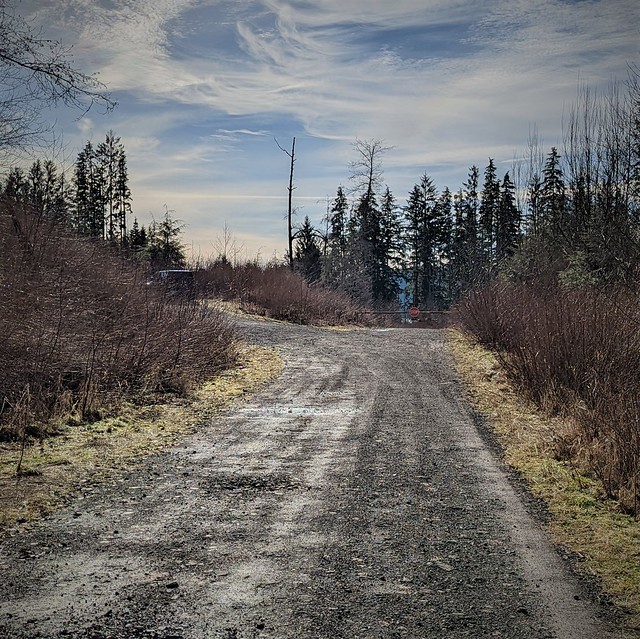
Speaking of scouting, I had one walk down the Coal Harbour main, this time to an area across the bay from Coal Harbour to check out some potential boondocking. There was a large area that I could see on the aerial photos that had been recently logged. I wanted to see if this might be my next boondocking spot.
Gate ahead. Vehicle parked on branch I’m walking up. Probably someone from town walking their dog.
Not far from the Coal Harbour main, I find the road ahead to the area I want to check out has a gate on it. The road does pass through private land here – being close to town, the possibility the road would be gated does not totally surprise me. It’s too bad, the area beyond the private property had a lot of branch roads recently logged that looked like good potential spots.

Branch road has branches
But the road branching off to the left is not gated or marked private. There is a vehicle parked there. Being close to town, I suspect it’s a local dog walker. They could be down the branch I’m going to explore, or down the gated road marked ‘private’. At any rate, I never encounter them and the vehicle is gone when I get back.

Dead end with the road blocked off boondocking spot
The branch road has brush intruding on the road in a few places – I’d have to do a bit of branch removal to get the RV in here not too scratched up. But I hit a permanent obstacle just a quarter kilometer down in the form of a large rock pile in the middle of the road. I can see people have camped here too – not surprising for being close to town. But it is a nice level spot on a dead end. I’d expect the possibility of the occasional visitor being so close to town.

Bridge mostly collapsed
Looking beyond the rock pile, I see why the road has been blocked off here. The bridge crossing the creek has mostly collapsed, leaving only enough bridge to walk across one bit. There would be no going further down this branch road with the RV at least. So much for exploring for boondocking spots. Between the gate and the blockage, all potential areas are inaccessible. Only this dead end at the blockage is a potential boondocking spot. At least it’s a decent spot – I make note to mark it in Google Earth, where I keep geocoordinates and notes on potential boondocking spots. But now I’m not certain I want to come here for my next boondocking location. Between the closeness to town (potential visitors) and the brush clearing I’d have to do, I’m not sure this spot is worth coming into. I’ll look at other areas when I’m back in front of a computer looking at aerial photos.
I’ve got lots of time left to explore, and the day is nice so I decide to continue beyond the bridge just to see what there is too see up this branch road. I know there are two branches of road up here, I’ll walk up both of them and see what kind of a view there is.

Tar layer is near the bottom of the vertical face
While the views at the road ends are not inspiring, I do see something of interest in this gravel pit. There are fused gravel layers with a black layer in between. Little bits of the black material have fallen to the bottom, but I’m not sure what I’m looking at.

Fossil below, found in tar layer I broke off
I climb up for a better view, breaking of a bit off the black stuff. Seeing it is gooey, I immediately realize I’m looking at a small tar layer, not unlike the Tar Sands of Alberta. I take a closer look at the tarry bit of rock I have broken off, and see what looks like vascular plant structure. Brushing a bit of the tar off, I realize I have found a bit of fossilized plant. The geological history seems to have had the area being an alluvial plain by the gravel below, then covered in what seems to be a reed like plant judging by the head I see in the roughly 8cm fossil I have found. While my find was unexpected, I shouldn’t be too surprised – being a coal bearing area fossils are always a possibility embedded in coal, or in this case, tar.

See the reed head pointing to the upper right
I clean up my find in a bit of water and photograph it when I get back to the RV. This is a fragile thing and may not survive the transport even well wrapped in a cloth. I’d been looking for fossils the whole time I had been out wandering about so far – to find it when I was not really expecting it was a nice surprise. I’m not feeling bad even about having taken a fossil – it was on a man-exposed gravel base that is now crumbling away being exposed to the weather. This fossil probably would have been eroded away soon as the exposed wall crumbles down.

How’s that working out for ‘ya?
I did go explore one more area for potential boondocking around Coal Harbour. But there was nothing suitable to be found. On the way, I did find this amusing sign among some garbage. I wonder if the sign went up after they cleaned up multiple times, hoping to shame those who leave garbage behind? You can see it is not effective in keeping the garbage away. I at least grabbed every can I could find and added it to the bag I carry with me. That’s my part to leaving things better than I found them, I collect cans from the side of the road. Every re-supply, I deposit them in a local recycling bin – even with crushing cans it is not worth it to go out of my way to collect the deposit. The reality of RV travel is $5 of cans is not worth going out of my way – the gas station can keep the deposit for their troubles recycling them.
So, while my explorations did yield some new boondocking spots near where I was parked, I decided it was time to try a new area. Read on to see what area I decided to try next based on my aerial photo sleuthing!
