
 The weather at Coal Harbour was about to turn very rainy. I had one more day of better weather to go explore down a road and see if I could get to Ruperts Inlet from my boondocking spot. Would I be able to hack it or would the bush thwart me? Where would I find snow?
The weather cleared enough that I decided to try one longer hike down the road to where it came close to the ocean, that being Ruperts Inlet. I had gone down the road before, but had seen no good way down to the ocean yet. I figured to give it one more try and see if there was an access down, as the road paralleled the coast about 250 metres away for a long stretch. 250 metres may not seem like much, but it is infinite when you are looking at impenetrable brush in between you and the ocean.
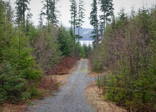
First glimpse of Rupert Inlet
I walked down the road which seemed to go straight to the ocean, but it veered off to the right just before getting there. A lot of elk and deer hang out here, the road is covered with their droppings. I was hoping if humans had not cut a trail down to the water, perhaps animals had somewhere. The road went up and down a bit, crossing little creeks on the low parts. Eventually, I came to a bridge over a larger creek. This looked a little more promising for getting to the ocean, but I still only saw the roughest of animal trail. I proceeded past the bridge, to another pit area. This was the closest to the ocean I was going to get following this road, so I walked around the edge of the pit, looking for an opening or trail down.

Brush is thick in places
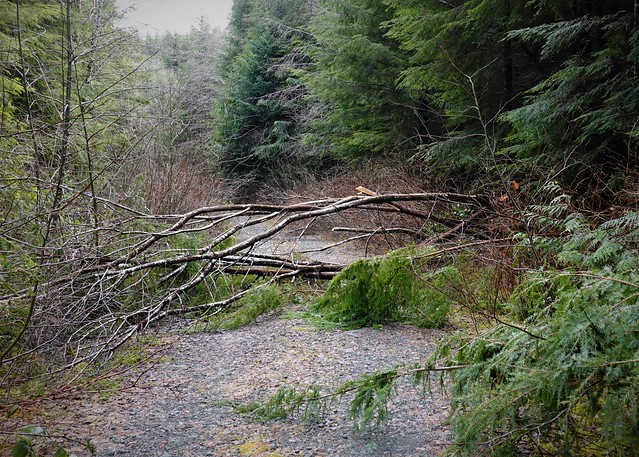
But everywhere was brush, no opening to be seen. Whenever I talk about brush, just refer back to this picture – it is all a variation on ferns and Salal mostly. The Salal could be way over my head in an impenetrable mass. This was a relatively open spot I tried to get through. I doubled back, coming to the bridge again. There is an animal trail there, but while an elk could crash through those bushes, it is too much for me. I cross the bridge, hoping for a better trail on the other side and finally spot something promising. It turns out to be a pretty good trail, just hard to spot from the road. I suspect both people and animals use it.

I finally make it down to the ocean. One problem: it is high tide and there is no beach whatsoever! I can barely get twenty metres down the shore climbing in among the trees. This is no good. I enjoy what little view I can see and head back to the RV. If I had a tidal fishing license, I could at least cast a little, but I have not yet attempted to find a place selling those.
I’m due for re-supply anyways. My plan after that is to head for Georgie Lake, an actual rec area campground. I figured it should be safe now the snow has mostly melted to head up there. My re-supply had me going right by a hardware store, I could see fishing supplies inside. I decide to stop in and inquire if they sold tidal fishing licenses. They did, so I got my license for the year, ending end of March. Not the most efficient of spending, but I wasn’t going to get caught somewhere on the ocean again not able to fish.
Of course, I was headed for freshwater now, no need for a tidal license, but there was a lot of exploring I could do between now and end of March, ocean fishing might still happen. I head out of Port Hardy, on the road to Holberg. The road starts out poorly paved, then quickly turns to gravel. What also quickly starts is the snow on the side of the road. There seems to have been a lot more snow here than where I had been, only twenty kilometres south of here. The piles from the plows on the side of the road are still massive, and it’s been a month of melting here. I see a fair bit of snow in the grass too.

About 30cm of hard crunchy snow on the ground here. No taking the RV into Georgie today!
I get to the Georgie Lake turnoff, and stop. The road has not been plowed, and there is a lot of snow still on it. The road goes down, with a track going through it. I briefly contemplate trying it, but while I’m sure I’d have made it to the bottom, I’m not so sure about back up. The snow could get deeper too – not bothering to check – I’ve had enough of snow!
Now I’m planning on the fly – I had not expected snow to keep me from my destination. I decide to try the next lake down the Holberg road – I didn’t see any good access on the aerials, but perhaps the trees hid something. I arrive at Kains Lake in short order, seeing through the trees. This is a pretty large lake, leading to my next surprise – it is frozen solid! Good thing I didn’t try the Georgie Lake road, likely Georgie was frozen too. I do spot a road heading down to Kains, but it the same problem – not plowed – too much snow. The road is also starting to turn from wet to icy – that is enough to prompt me to turn around at the first good opportunity. I’m not going to Holburg on the chance everything around there is snowed in, not to mention the iffy road.
Then a light bulb goes off. I just got my tidal license, why not go back to my previous campsite near Coal Harbor and try some ocean fishing? There were still some brushy roads I could hack my way through, plus I’d never actually walked into Coal Harbour, only a 40 minute walk from my campsite. Mind made up, I head back. This is the first time I’m returning to the exact same spot for a second week, but at least I have been around here long enough now to have spots I can visit if things don’t work out for me in my exploration.
I only took out enough to be able to climb through
My day ends back where I started, early too. I have time for a little “road improvement” project. Since I’ll be going back down the road with my pack and fishing rod, it would be nice if some of the more difficult to pass trees on the road were made less difficult. So me and my axe take a little late day stroll down the road to the more difficult trees. A bit of swinging later, and trees are either gone or have large holes I can climb through now, not catching my rod on every branch. The next dude with a proper chain saw can cut the rest of those monsters down and make the road passable again.

The next day, ocean fishing beacons. As I make my way down the road, I see my first sign of spring, pussy willows! Actually, I don’t think these are real pussy willows, but they look similar. I marvel at the difference twenty kilometres and a hundred feet of elevation make. Here, life is coming back to the forest and it is fairly pleasant today. Where I had wanted to go, there was still a foot of snow on the ground and lakes were frozen.

I make it down to the ocean and this time, the tide is out. I made sure to check before this time! Across the inlet from is the Varney area, where I previously camped in a couple of spots.
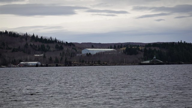
Buildings remaining from the former Island Copper mine
I’m pretty close to the former copper mine. There are still a fair number of buildings on the site, being used for something. I could hear the music blaring from the outdoor speakers as I walked down the road to the ocean. The road passes within a half a kilometer of the site before turning away to where I was.

The grassy area is where the campground was
Almost across from me is the Varney log dump campground I hiked to. You can see it would be easy to access by boat.
I spent some time walking and fishing my way down the shore, keeping a careful eye on the rising tide. I don’t want to get caught with no shore to walk back to my trail access. There were no fish to be had – not surprising as they tend to be a bit further out than I can cast, and I’m not really fishing with good salmon gear for sure. It is a bit blustery out and overcast, but no rain! I’ll take what I can get.
The following day was just too wet to head out. Having internet here makes the days fly by. I can always find entertainment online, as well as getting ahead on my blogging. The following day was a little drier – the rain let up for a while so I decided to head out for a short walk to a branch road closer to Coal Harbour that looked like it might have some boondocking.

Good road going up from the main
The road in off the Coal Harbour main went up steeply, but the road was good. The forest is mature – might be only a few years until they log this bit too.

Start of the bad road, gets worse past the junction ahead
But as you pass a turnout and enter the more recently logged area, the road becomes much rougher. It is like they laid much less gravel down, and just relied on the log base to hold things in place long enough to log the area. I’m wondering, is this a cost cutting measure, or something to discourage people coming in, or a bit of both? It would be difficult to drive any of this with an RV, more uneven ground and logs sticking out appear as you go past the first branch. If I was motivated enough, I’d try this to get to the end of the first branch only.

But why try when you have this little turnout just before the logged area starts? It is a nice level spot, although there is some garbage down in the trees. It seems this spot is close enough to Coal Harbour that people have brought their garbage out here. There probably are a few Friday night drinking parties with the town kids here. Overall, I’d have no problem staying here a few nights, especially since the cell service is at least 2/4 bars. I returned to my RV as the rains were coming in again.
The weather was improving again after the rainy days. There still were some things to explore on my second round near Coal Harbour. See you next time when I go explore Coal Harbour, do a little fishing, and find a fossil!
