

Georgie Lake sunset
When I was starting to plan my journey to the north end of Vancouver Island, I had seen that Georgie Lake rec site was the farthest north site on Vancouver Island that was still fairly close to civilization and paved roads. I mentally had this location as a goal for how far north I would go at the minimum. But my previous attempt to visit had been thwarted by snow. This time, I was sure the snow would be gone, I would finally make my northern destination for my winter travels on Vancouver Island.
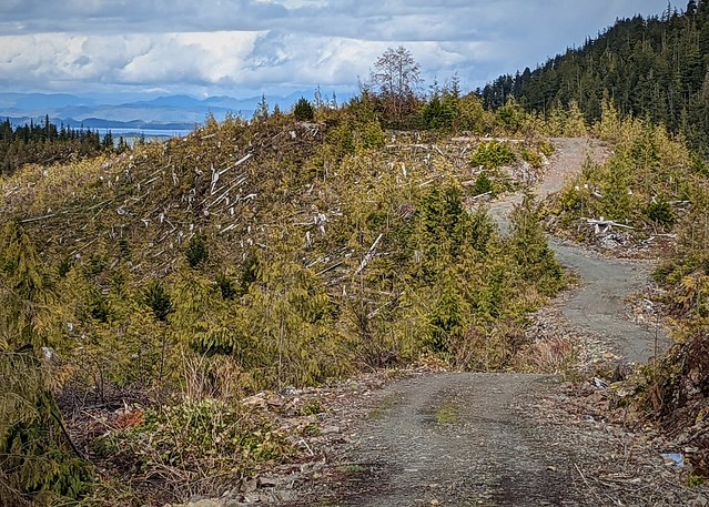
My journey up to the Georgie Lake turnoff was much more encouraging this time. There was no snow on the side of the road, although a bit of drizzle meant I had a muddy RV yet again up here. The Georgie Lake road was free of snow this time, although even with all the rain and early spring warmth, there was still a bit of snow on the sides where the plough had piled it up on a previous ploughing before they stopped and just let the road get snowed in. I was happy that I saw no evidence of logging trucks on this road. The main road to Holberg is mostly wide enough to allow passing with an approaching logging truck, but a few narrow spots meant I’d rather not see a logging truck coming my way. So far, so good, no logging trucks were encountered while I was on that road.

Partial Georgie Lake view
I breathed a sigh of relief upon turning onto the Georgie Lake Road, as I could see it did not get a lot of traffic and I was not likely to encounter logging trucks on this narrower road. Arriving at the campsite, I scout it out before deciding on my spot. The campground is not very big, around ten sites. The lower branch goes right to the lake and I figured might get some traffic, so I chose a spot on the upper branch, with only a partial view of the lake, but likely no one else coming in to visit or camp.

Looking to Boat Launch
As a BC recreation site, it has the standard facilities, although in this case, the picnic tables and fire pits were missing from some of the sites. The sites are mostly small – I’d rank only a couple in the upper section as being able to hold larger rigs. The lower sites are closer to the lake and have partial to full views. There is a bit of a sand beach, and a jut that you could launch smaller boats from. That jut also was a good spot to fish.

Cell service to the left, no service to the right
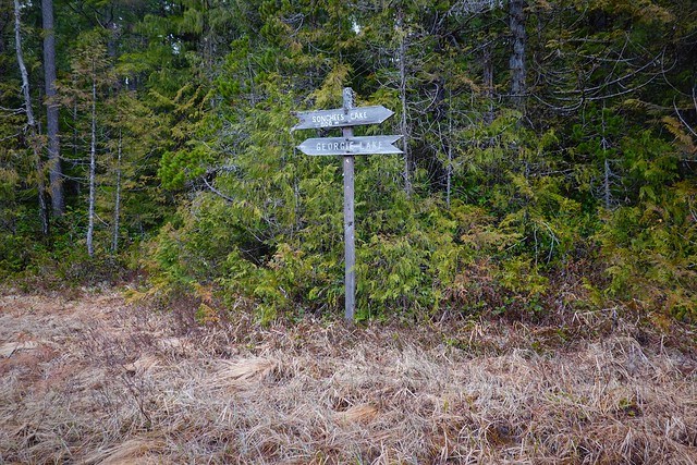
I could see from the cell service map of Telus, that Georgie Lake was just off the service area. Unfortunately, the map is right this time and no service could be had even with my booster at the lake. I could walk back ten minutes down the road, where a sign informed me that there was cell service. A modern sign of the times. A little further back a road with a sign pointing down it to “Songhees Lake” turned off. While I had cell service by the sign, I figured out where Songhees Lake was, and decided to give it a try to follow the road down to the lake. It would be a long walk, perhaps too long for the time I had, but I’d see.

Borrow pit to the left, where I ended up staying later
Starting down the road, I quickly came to a borrow pit. It looked good for parking my rig and it had cell signal. I resolved to come back here after resupply as I needed to be within cell signal again to deal with bills and taxes. The world does not go away just because you are out travelling!

Right branch leads to some boondocking, straight is my travel direction
I came to another branch, with another sign pointing me to Songhees Lake. Continuing down that, I am hoping the road turns directly to the lake following the power line from what I can see on the googles aerial. But no, the road continues down the valley, and I see it will loop back the long way to the lake. But I still have a lot of time – I decided to continue on and see how far I’d get.
View down the road to the ocean
I continue down and see the ocean way ahead with some islands. I no longer have cell service, but my googles cache is good enough to tell me I’m looking at God’s Pocket Marine Park. Eventually, the road turns back towards Songhees Lake, now going up the valley the lake’s creek exits out of. I have to gain the elevation I’ve dropped but it’s not too bad. The weather is nice, so I’m maxing out my time, hoping I can confirm lake access, and a possible loop back to the campground.

Road ends at a ditch, WTF?
As I think I’m getting close to the lake, the road suddenly ends at a sharp drop to gully with a little stream. I can see cleared forest beyond. Looking at my googles, it shows the clearing, but not going all the way to the lake. I drop down the gully, and cross over to the other side, looking for a trail. There is nothing. I decide I am not going to slog through roughly cleared forest, to only have to also slog through dense forest to get to a lake that may or may not have a trail back to my campground. Even though I’m close, it will be the long but sure trudge back down the road and around to my campsite. Why they have these signs up pointing you to the lake when the road is not finished is beyond me.

Looking out to God’s Pocket Marine Park
But the walk back is good, with the sun out I get a good picture of the view out to God’s Pocket. Thanks to my long detour, the road gets fairly close to the ocean but still high enough to give you a good view. This is probably the only reason to come down this road in my opinion.

Georgie Lake sunset

Earls Bridge sign is so dark even fill flash would not light it up enough
I return to my campsite good and tired, but I still manage to get down to the lake to properly appreciate the great sunset while I do a little fishing. From my research at the internet sign, I find out that the trail starting at “Earl’s Bridge” does actually go to Songhees Lake. Having gotten so close, I must get to this lake now and see what the fishing is like. But the forecast for the following day is iffy – scattered cloud with possible showers in the morning degrading to showers in the afternoon. I decide that with light rain gear to cover the showers I could head over. I had already explored down the trail a little ways and saw it was in bad shape, far worse than the stuff I encountered at Beautiful Bay. Even though the hike was only supposed to be a little more than three kilometers, I started after breakfast, taking my lunch with me in anticipation of a long hike. Plus, I wanted to allow as much fishing time as possible if the lake turned out to be good fishing.

1km is still along Georgie Lake
The hike along Georgie Lake is not too bad. The trail wanders close and away from the lake. You pass some good potential fishing spots along the way. But every boardwalk, bridge and cut log needs to be treated as if it will collapse when you step on it. Some of them are also crooked, leading to potential slip hazards. It was slow going, I knew this thanks to the “1km” marker sign on the trail. Good thing I’d left myself lots of time to get to the lake. The weather had so far held to the forecast, occasional showers and cloudy. All the Salal brush overlapping the trail was making me wet, but I had my rain pants on to stay dry underneath!

Partly covered boardwalk and trail marker

Slippery and crooked log crossings
The trail eventually turns away from Georgie Lake for good, taking you uphill to cross over to Songhees. The brush is even thicker here and the trail becomes faint enough to be in danger of being lost. But the trail markers are quite good – metal markers that are easy to spot. There are only a few places where I suspect a marker has fallen off from age that you find yourself casting about a bit for the next marker and trail. What is left of the boardwalks has rotted to a point here that you just walk beside the remaining rotten bits in places. Other areas where there is standing water require one step at a time, testing your weight to make sure the remaining structure isn’t going to collapse on you. The uphill and downhill parts have slippery logs too – sometimes I step off just to avoid slipping and falling off instead.
 Having passed the 2km marker, I come to a place with left over old snow. I’m a bit surprised as I expected anything not plowed would be gone by now. There must have been a lot of snow around here for this little patch to still be here. But my bigger problem is that the trail has faded away to nothing here. It is a bit open here, looking in the direction of the open ground I see blue flagging tape ahead – that must be the way. There is no bridge over the one significant stream I need to cross. I walk up and down, but find nothing better than a long jump I might slip up on. Sure enough, jumping over I get one foot soaking wet stepping a little too close to make my jump over. The rain is starting to come in now too. My prospects of getting dry are not looking good.
I found no trail in the Georgie Lake direction
I continue up the clearing – there is a bit of faint trail to be seen once in a while, and the blue flagging tape continues. My googles aerial shows me moving the right direction, so I’m not to concerned, yet. Then I come to this big set of direction signs. I must be on the right path such as it is then. The clearing is a bit of a T intersection here. Heading in the direction the Songhees Lake sign is pointing, I saw the trail starting up again faintly, becoming more distinct as the markers appeared again leading me into the trees.
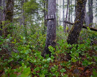 The trail goes up over a little ridge, to drop you back down to Songhees Lake. There are stairs of sorts carved out of a log that I attempt to use, even though it is a bit crooked. Even in my caution I manage to fall off the stairs, but catch myself without falling face down or breaking a bone. The falling rain has made things super slippery now. The 3km mark passes and I know I’m getting close. But I manage to fall again on the treacherous infrastructure. Time to avoid the more crooked remaining bits if at all possible.

This was taken further down the line at the end of the road
I cross into an expected power line clearing. There is a bit of a “road” if the log base laying there can be called that, but the trail picks up on the other side only a little ways down to the left.
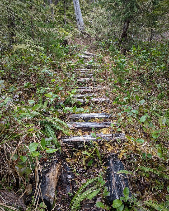
Making my way through the forest again, I use or avoid the remaining bits of trail infrastructure on a case by case basis. The trail drops steeply in one section, fortunately the ladder/stair type thing there is still in good shape to help with the scramble down.

I spot Songhees Lake at last through the trees. Walking down I see only a bit of disturbance from previous visitors. There is no shelter even from the trees, which is too bad as it is really raining now.

Looking down Songhees Lake. The other direction leads to the river coming in
I have lunch and then give fishing a try, for 1.5 hours on the timer. Any longer and I’m risking running out of time coming back. There is nothing biting on the lake whatsoever, a real bummer for such a difficult hike. The rain just keeps falling relentlessly, leaving me with nothing much for pretty pictures either. I decide to pack up a little early and head back, with a detour down the powerline clearing to the river connecting the two lakes. I want to see if you could navigate with a boat, for future reference.

Not long, Georgie Lake is visible in the back here, and the rapids only go the same distance again the other direction
Of course even the rough powerline road ends 200m before the river, making the last bit of travel take ten times as long climbing over tree bits and rough ground. But I get to the water and see rapids between the lakes. You definitely could go down them in a kayak, or small boat perhaps, but no going back up. A portage over the rough ground in the powerline clearing is required. It’s not long, but like I said, even a 100m in that mess is a challenge. I saw no trail, perhaps there is a better path on the other side of the river. Even though that was a tough slog to get to the river the information was worth it. If I come back to Georgie with a watercraft, I know I’ll have a challenge if I want to go over to Songhees Lake.

Of course the following day dawned with blue skies. It would have been a much better day to go to Songhees Lake. That is the way it goes sometimes. While I’d normally end this post around here I’m going to do a longer one for the whole Georgie Lake area this time. My stay was shy of two weeks, and a bunch of that time was inside avoiding the rain, and doing taxes and bills. Not going to blog about those. So, you get 1.5 posts in one.
There were a few people that came out to Georgie Lake just for the day. I saw several mothers and their children out to enjoy the beach. I met Aldin, a university student on spring break who was fishing one morning with me while his buddy stayed at camp. He was out from Victoria, exploring around the area. Even camping free, it wasn’t a free trip – gas cost them $200 from Victoria to the north end of the Island driving a minivan. Gas is $2/litre right now. I was not looking forward to my next fill up. Another morning I met Craig from Abbotsford, living out here for the first year now. Unfortunately that meant he couldn’t give me much in terms of local fishing tips. He could offer though that the lakes near Vancouver are very busy during the on season now – practically elbow to elbow in the good spots. I’m avoiding that area on the way out – not worth it until I have some sort of watercraft with me again.

29cm Rainbow on a Panther Martin silver spinner and body with a yellow/black/red fly on the hook
The nice day following my wet hike had some fishing results too, a 29cm rainbow that was a bit thinner than the one I caught at Kidney Lake. Turned out not as tasty either, but still not bad.
 As I mentioned, there was a fair bit of rain, and it got cold too. I went to bed one night with mixed snow and rain falling, and awoke to snow on the ground. While it is not what I wanted to see, it was not totally unexpected, I was up 200m now and snow is still a possibility in March here. The snow at least melted during the day so I could go back to thinking spring thoughts in BC.
 I switched over to the borrow pit spot I had found on a Monday, short of my usual week stay. I had business to take care of in the civilized world – walking ten minutes to get a signal everyday wasn’t cutting it. The pit area was about 15 minutes from Georgie Lake, at the start of the road that does not quite go all the way to Songhees Lake. I was surprised how much traffic went down there. I expected a car or two out for a drive, but there were a few work vehicles and a work trailer coming down too. Some work was happening down there somewhere on the road. But the rest of the time, now that I was connected to internet, was spent mostly dealing with taxes, bills and business.
 The fact that it rained a lot helped me focus on business at least, but there was always time set aside for a little walk each day while the weather was a bit better. A few other boondocking spots were found in the area, but nothing that much better than the pit I was in. There is one dead end a little further back from Georgie Lake I might try – no being on the side of the road there and it is just far enough in to not be visible from the road.

The cougar was enjoying this sandy hill just before I got there…
Can you see the cougar print in the sand here? Particularly his fresh claw marks? I was out for an evening stroll on my last day and the light was starting to fade. I was on an overgrown power line road, actually the other end of that one that I was on at Songhees Lake. The rain had stopped less than two hours ago, so I knew I was looking at something really fresh, in fact I might have displaced the cougar just now. While I’m not too worried about cougars, I’m not into goading them on. I left the overgrown power line road and hightailed it back to the RV, checking behind me once in a while to make sure I was not being followed.

But I did manage to get one good sunset picture before I left the vantage point. Tomorrow was going to be the beginning of my move off the island, heading south to Woss Lake Campground to start with. I would have liked to have stayed a little longer and enjoy the spring on North Vancouver Island. It is a wonderful area that has the rare combination of beautiful scenery, enough amenities to get by, but not (yet) overrun by people. I’ll be back, but in the meanwhile, I have a new journey planned. Join me next time on my first stop on my new trip, at Woss Lake.
